Transmission corridors on BLM land
December 26th, 2024
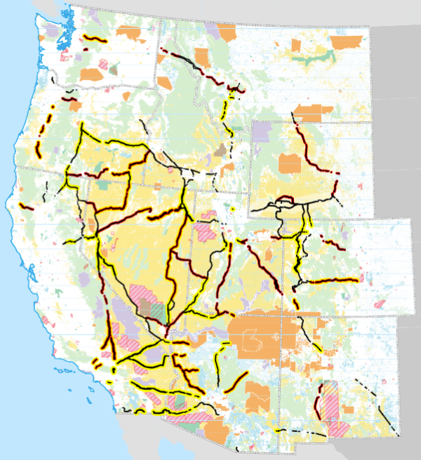
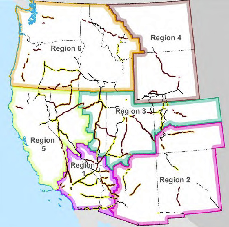
Recent alert came over the wire about a transmission project on Bureau of Land Management (BLM) land, this one in Wyoming, and it’s to be built “mostly” on BLM transmission corridors. WHAT? Yup, here’s the main page. BLM transmission corridors And yeah, it’s grim. That map above shows how grim it is.
So before I get into Lucky Star Transmission, we need to get familiar with the BLM set up… and there’s a LOT. It’s originating with the “Energy Policy Act of 2005” There’s so much info that the BLM Lucky Star Transmission Project will be the next post. Lots of ground to cover — and they’re sure working on covering it with transmission. Ya wonder why challenging transmission projects feels hopeless, other than minor route changes…
Did you know the feds designated the “West-Wide Energy Corridor, a BLM-designated energy-transmission corridor,” over a decade ago? This is another aspect of the “Energy Policy Act of 2005.”
That Energy Policy Act of 2005 is the law that triggered the coal gasification rush that thankfully was brought to a halt, particularly thanks to everyone of “No New Coal Plants,” challenging every one of them, and helping establish that coal gasification was nothing more than “Pipedreams of Green and Clean,” and that claims of feasible carbon capture and storage was not happening on a level to be even close to a CO2 climate change miracle.
As for CO2… CO2 capture and storage is a recurring nightmare, a red herring that keeps coming back.
It’s so disturbing to see the same ol’ thing coming around, after the intense challenge to the Excelsior Energy Mesaba Project, where Xcel Energy, of course, and our local advocates mncoalgasplant.com(pre 2012 captures) and Citizens Against the Mesaba Project (CAMP)(pre 2012 captures) worked together to tank Micheletti’s boondoggle. At the last minute, Excelsior Energy camp up with a CO2 capture and storage plan, where it would capture a minute percentage of CO2 and then transfer it to the PLANT GATE!Their plan? Read it and guffaw, snort, hoot and holler: Ex_EE1067_Plan for Carbon Capture and Sequestration
From nearly 20 years ago, that was a nightmare I don’t really want to remember: Pipedreams-of-Green-Clean-IGCC The Excelsior Energy Mesaba Project was an all encompassing HUGE project for me and all of us challenging coal gasification, time wise, technically, and the sheer room for all the boxes of crap taking up an entire wall in my office… and OH MY DOG, I missed a lot that grew from that Energy Policy Act of 2005.
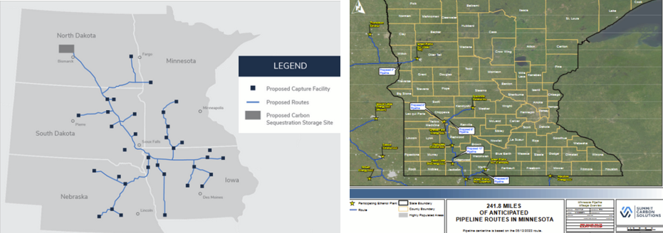
The current push for CO2 capture, pipelines, and storage a la Summit Carbon Solutions, is another pipedream/nightmare, proof that “we” don’t learn anything. The Iowa parts of Summit Carbon Solutions pipeline project was APPROVED (!) by the Iowa Utilities Board f/k/a Board of Public Utilities last summer, and the Minnesota Public Utilities Commission recently approved a very short part of Summit’s pipeline, I’d guess a Summit trial balloon for Minnesota, as a much larger pipeline project is proposed for southern Minnesota. Sooooo… we’re off to the races.
And that brings us to the transmission part of the Energy Policy Act of 2005. National Interest Electric Transmission Corridors we know about. The original three are now joined by others, also receiving a big push right now by the Biden Administration adding some additional corridors, and dropping others proposed.
But these BLM “energy corridors” are a whole ‘nother kettle of fish. When first established, they were challenged, with Plaintiffs arguing it wasn’t enough, hence a “Settlement Agreement.” Y’all know what I think of “Settlement Agreements” and this one seems no exception — look at all the groups blessing this BLM facilitation of another massive transmission buildout:
Here’s the BLM’s “Regional Report” with links to the documents:
Regional Review Final Report
And the map of the corridors:
Here’s their guidance for siting transmission in these corridors:
Interim Directive 2726.43k – Use of 368 Corridors in Siting Energy Projects
And here’s their study, which supposedly evaluates whether the Section 368 corridors are achieving their
purpose to promote environmentally responsible corridor-siting decisions and to reduce the proliferation of dispersed ROWs crossing Federal lands.
From this, the “priority corridors” map:
Ain’t this just delightful??
On to the Lucky Star Transmission Project
Hot off the Press — Push for NIETC Transmission
December 16th, 2024
FYI, not related, here’s a close-up of Minnesota, transmission maps found at https://gem.anl.gov/tool/ and click on the transmission layer (takes a while to load):
A press release just hit the inbox, days after Oklahoma was able to stop declaration of a National Interest Electric Transmission Corridor through the state — the DOE withdrew the designation. Good idea.
A massive power transmission line project was canceled following public outcry
So here they go, pushing this — deja vu all over again:
Federal Register publication HERE.
It doesn’t say “Send comments here” so… it does say “for more info: Christina Gomer, Senior Technical Advisor, by email at NIETC@hq.doe.gov or by telephone at (202) 586- 2006.” I’ve sent a missive to clarify, but ?? Will post here when/if I hear something new.
HA! Here’s the response that I received:
There’s no “addresses” section of the Federal Register Notice that I can find. Here it is, see for yourself: https://www.govinfo.gov/app/details/FR-2024-12-16/2024-29419/summary
HERE’S THE INFO, from the link above (https://www.regulations.gov/document/DOE-HQ-2024-0096-0001), which is NOT linked in the Federal Register Notice:
Color me pissy…
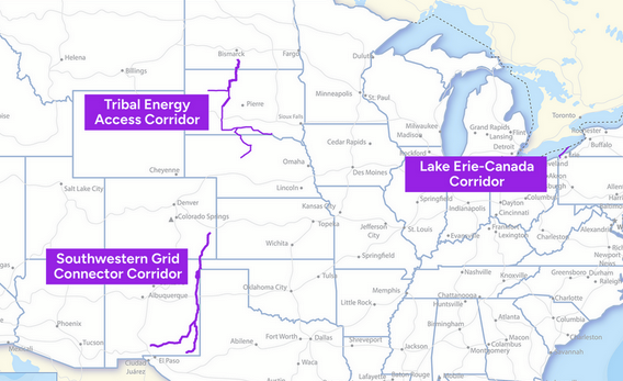
Here are the 3 corridors they’re talking about. The one crossing the border into Canada at the right hand side of that “Lake Erie-Canada Corridor” label is short, pretty tough to see, so click on the map for a version you can enlarge.
Here’s how they fit with other big transmission — the proposed NIETC corridors are the blue lines on this map:
Anyway, below cut and pasted from the DOE press release in its entirety. Comment period is OPEN. Check this out and COMMENT, here’s the poop, and NOT in the Federal Register Notice:
Biden-Harris Administration Announces Three High-Priority Areas Advancing in National Interest Electric Transmission Corridor Designation Process
DOE Seeks Public Input on Proposed Public Engagement Framework and Possible Scope of Analysis for Areas Moving to Phase 3 of Designation Process
WASHINGTON, D.C. – In a continued effort to expedite the build out of a resilient and reliable electric grid, today the U.S. Department of Energy (DOE) released a list of three potential National Interest Electric Transmission Corridors (NIETCs) moving to the next phase of the designation process. A NIETC is an area of the country where DOE has determined the lack of adequate transmission harms consumers and the development of transmission would advance important national interests in that area, such as increased reliability and reduced consumer costs. DOE recently established a four-phase process for NIETC designation; the potential NIETCs moving to Phase 3 of the designation process are:
- Lake Erie-Canada Corridor, including parts of Lake Erie and Pennsylvania
- Southwestern Grid Connector Corridor, including parts of Colorado, New Mexico, and a small portion of western Oklahoma
- Tribal Energy Access Corridor, including central parts of North Dakota, South Dakota, Nebraska, and five Tribal Reservations
These potential NIETCs have been significantly refined since the release of the 10 potential NIETCs in May 2024, and each were renamed to better describe their location and purpose. DOE made these refinements in response to comments received from the public and its continued analysis of the value of NIETC designation to spur needed transmission investment.
A lack of transmission infrastructure can directly contribute to higher electricity prices, more frequent power outages from extreme weather, and longer outages as the grid struggles to come back online. In 2021, the Bipartisan Infrastructure Law amended the Federal Power Act to authorize the Secretary of Energy to designate any geographic area as a NIETC if DOE determines that consumers are currently harmed by a lack of transmission in the area or are expected to suffer harm from a lack of transmission in the future. DOE may also consider whether development of new transmission would advance important national interests for that region, such as increased reliability and reduced consumer costs, when designating NIETCs.
In December 2023, DOE’s Grid Deployment Office announced a new four-phase process for designating NIETCs. The process aims to maximize opportunities for public input throughout each of the phases to help DOE identify narrow geographic areas where transmission is urgently needed and where NIETC designation could help accelerate solutions.
DOE initiated the first phase of the new process by opening a public comment window for suggestions on where DOE should consider designating NIETCs. In May 2024, DOE initiated Phase 2 of the process by releasing a preliminary list of 10 potential NIETCs, including maps with rough approximation of boundaries and a high-level explanation of the transmission needs within the potential NIETCs. DOE also opened a public comment window.
The announcement today initiates Phase 3 of the designation process, the public and governmental engagement phase, during which DOE will continue to refine geographic boundaries, determine the appropriate level of environmental review for each NIETC, if any, and conduct any required environmental reviews under the National Environmental Policy Act (NEPA) and other applicable federal statutes, conduct robust public and governmental engagement, and prepare draft designation reports.
Additionally, DOE is aware of potential impacts to military testing, training, and operations and will continue working with the DoD Military Aviation and Assurance Siting Clearinghouse to address these impacts as these potential NIETCs are further refined in Phase 3.
DOE is also publicly releasing detailed maps of each of the three potential NIETCs moving to Phase 3, including underlying geographic information system data. A 60-day comment period is now open to solicit comments on DOE’s proposed public engagement framework and possible scope of analysis of the potential NIETCs, including environmental, cultural, or socioeconomic effects should DOE designate any of the potential NIETCs. Additional public engagement will occur after this initial comment period. In addition, DOE is providing the names of known transmission projects under development within the potential NIETCs, as well as anticipated next steps of the NIETC process.
DOE combined and refined the boundaries of four of the 10 potential NIETCs from Phase 2 to form the boundaries of the three potential corridors proceeding to Phase 3. The following potential NIETCs announced in Phase 2 are NOT moving forward in the designation process:
- New York-New England
- New York-Mid-Atlantic
- Midwest-Plains
- Mid-Atlantic
- Delta-Plains
- Mountain-Northwest
DOE’s decision to not move these potential NIETCs forward does not constitute a finding that there are no transmission needs in these areas; rather, DOE is exercising its discretion to focus on other potential NIETCs at this time and may in the future revisit these or other areas through the opening of a new designation process.
Public Engagement Opportunities
In January 2025, DOE will host informational webinars on each of the three potential NIETCs:
- Tribal Energy Access Corridor Webinar: Tuesday, January 14, 2025 at 3:00 p.m. Eastern
- Southwestern Grid Connector Corridor Webinar: Wednesday, January 15, 2025 at 3:00 p.m. Eastern
- Lake Erie-Canada Corridor Webinar: Thursday, January 16, 2025 at 3:00 p.m. Eastern
Registration is required. Registration for each event will remain open until the event starts, and recordings will be made available online.
After the close of the public comment window on February 14, 2025, DOE will review comments and create tailored public engagement plans for each potential NIETC. DOE will determine its obligations under applicable environmental laws in Winter and Spring 2025, and then proceed to conduct any required environmental reviews. DOE will continue to accept meeting requests, public comments, and questions on the potential NIETCs throughout Phase 3. After further evaluation during Phase 3, DOE will release any draft NIETC designation report(s) and any required draft environmental document(s) and intends to request public comments on both.
Register to receive NIETC designation process updates here.
Learn more about the Grid Deployment Office.
MISO drops another load of transmission
December 13th, 2024
Here it is, and I’ll point out a few things — I really don’t have the stomach for digging into this too deeply, it’s that nauseating.
MTEP24 FULL REPORT
Here is the list of the above projects, with named substations, voltages, and estimated costs (p. 163):
More on this later… I cannot bear to go over this in any detail. 765kV through Minnesota?? URP!
Xcel/Northfield Draft AUAR released!
July 20th, 2023
Scoping for the “Northfield AUAR” ended a while ago, and now, it’s the DRAFT!
DRAFT AUAR HERE
Comments are due Thursday, August 17, 2023 at 4:30 p.m.
Send comments to Northfield, and I’d recommend you also send to Xcel and Stantec:
- Northfield: Mikayla.Schmidt@ci.northfield.mn.us with Xcel/Northfield Draft AUAR in the subject line, or if hard copy, Mikayla Schmidt, City of Northfield, 801 Washington St., Northfield, MN 55057.
- Xcel Energy: Jacob.N.Ander@xcelenergy.com
- Stantec: Erin. Sejkora@stantec.com
Of course, it gets my attention whenever Xcel does anything, and this large AUAR, on the northwest edge of Northfield sure got my attention. My comments, sent in February (5 months ago!):
This AUAR got my attention because it includes a “data center” option:
Note in Development Scenario A, the “Technology Center” takes up 538 acres, the majority of the area:
And what caught my attention initially was that this popped up around the time that Xcel was going back and forth about a big data center near the old Sherco plant site. Then that application was withdrawn.
Funny thing though, two dockets appeared, filed by Xcel, M-22-572 (CONTRACTS FOR PROVISION OF ELECTRIC SERVICE TO A NEW LARGE CUSTOMER’S MINNESOTA DATA CENTER PROJECT), and M-22-579 (CONTRACTS FOR PROVISION OF ELECTRIC SERVICE TO A NEW LARGE CUSTOMER’S MINNESOTA DATA CENTER PROJECT), with Xcel Energy filings in November, 2022. The two initial filings by Xcel in these dockets are both pdfs of 142 pages, 137 of those the Petition and tariff provisions. They seem identical, but I’ve not gone over page by page.
What I do note, in these days of focus on energy conservation, is the load predicted, on page 6 of both, expecting quite a load suck:
“The initial data center Premise is expected to achieve an initial load of at least 10 MW and grow to exceed 75 MW by the end of its first 10 years in service.“
It’s important to consider the electrical service to these sites, locations unknown. What new infrastructure would be needed? One data center I know of was set in the middle of Glencoe, and is a nuisance to neighbors, violating the MPCA’s noise standards. How is location of data centers determined, what factors are considered? With the Northfield AUAR proposed by Xcel, in the Xcel service territory, and anticipating 538 acres for a “technology center,” it’s at the very least within the realm of possibilities.
The most recent posting in both of these dockets was from “Amber Kestral” (reminds me of the names for transmission line conductors!), not Xcel.
There were identical one page filings from “Amber Kestral,” stating a request for a pause:
In transmission, we’ve noted for decades that “it’s all connected.”
Do review the Xcel/Northfield AUAR and send in comments by August 17th!
DRAFT AUAR HERE
Delaware cancer rates — note 19731
July 4th, 2023
Yes, every picture tells a story, worth a thousand words… Alan Muller, Green Delaware, spent decades fighting the polluters of Delaware, concentrated in New Castle County, and the Indian River coal plant way south (and surrounded by cancer), and many other polluters in Delaware and beyond.
A few maps of Delaware cancer rates… from this article about articles in the Snooze Urinal (as Alan calls the News Journal):
Cancer Clusters in Delaware? How One Newspaper Turned Official Statistics into News
Alan’s Port Penn, DE is in this area on the bay, just south of the C&D Canal, dark red in the map above, dark blue in the maps below:
Cancer Cluster Investigations in Delaware
And from the state’s Division of Public Health:
CENSUS TRACT-LEVEL CANCER INCIDENCE IN DELAWARE, 2015-2019
Port Penn, DE is in the dark blue census tract on eastern edge, south of Delaware City, that bumps out into the Delaware Bay (166 incidence rate on map):