Maps at Goodhue Co. Mining Committee
October 1st, 2013
Very interesting…
Here is a copy of the map at issue at the Goodhue County Mining Study Committee (see below too):
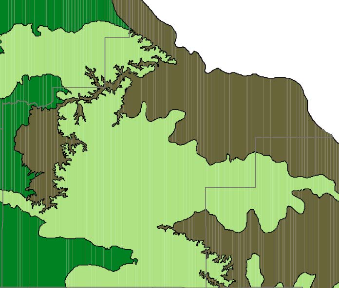
Ecological Subsections Map
(a similar federal one can be found at http://upload.wikimedia.org/wikipedia/commons/8/8b/Minn_ecoregionsmap.pdf, for origin, see http://en.wikipedia.org/wiki/List_of_ecoregions_in_Minnesota)
This map was presented to the County Mining Study Committee at its last meeting. At issue is how this would be used — the DNR’s boundary is clear, and more specific on other maps somewhere, and a more detailed map with additional layers is likely within the county resources already. Is it a matter of:
- a prohibition of all mining in the grey/green; or
- prohibiting silica sand mining in the grey/green; or
- more intense regulatory scrutiny of proposals in the grey/green; or
- some other option?
I’d vote for the first, with the second as a fall-back.
Use of this map as guidance is a big step forward because it isn’t an arbitrary boundary (a distance is arbitrary), instead it’s one delineated by the DNR (and a good reference for the EQB Standards and Criteria), not just an arbitrary distance. The County is sensitive to the need for this support because of the issues over the wind 10 RD setbacks and loss at the PUC and Appellate Court. They need to be able to refer to something and say, “This is why!” These maps do just that. It’s based on science, it’s based on research of the state agency with the expertise, it’s easy to establish whether something is or is not in the zone, and it’s supportable and defendable in court.
So what it looks like for Goodhue County, without any other layers, is this:
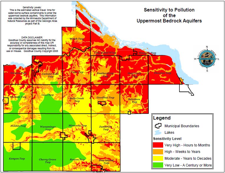
In addition, there’s this “Sensitivity to Pollution of the Uppermost Bedrock Aquifers” map which I’ve not seen before. It’s on the County site, and look at the red “Sensitivity level – very high, hours to months” which should be referenced (it’s similar to, but more dramatic, than the MN Dept. of Health map about nitrate contamination):
Kristen Eide-Tollefson has told me that there’s a Water Sustainability Framework Report, and with directions, lo and behold, I found it (still downloading, must be very large with the maps, won’t download as pdf, grrrrrrrrrrr, firefox has locked up twice):
When you look at big picture, which our aquifer is, there’s nearly universal support for protecting the aquifer, and it’s pretty hard to credibly argue against protecting it. There’s a lot of good information, various maps and studies, to support protections, and that’s important because if the county’s ordinance is challenged, as it has been before, it has to be defendable. Protection of the aquifer is the protection of our natural resource that does something for the entire county.
The Mining Study Committee seems to be on a good track here, looking at bigger picture and stronger regulation moving toward prohibitions.
These maps are also oh-so-relevant information that should be considered by the EQB for the Standards and Criteria that they’re reworking.