Not-So-Great Northern Transmission
November 8th, 2012

Got that? NO hockey sticks in the hotel!
Yesterday, both meetings, in Hermantown and in Grand Rapids, were well attended. The Hermantown municipal building is new, nothing like that was there last time I was in town, it’s been a while. Very nice building, wonder if Minnesota Power’s Arrowhead transmission line had anything to do with that?

Here are copies of what I’ve been handing out:
Notice Plan Comments are due November 19, 2012, and Reply Comments due December 10, 2012. Send to burl.haar@state.mn.us, with “Great Northern Notice Plan Comments – Docket 12-1163” in subject line.
Minnesota Power’s Notice Plan for Great Northern Transmission Line

I’ve been looking for the studies that support this line, made some progress, but not enough, MISO has a page on the Northern Area Study. Here’s the kind of map I find interesting, one that shows the flows and areas where they want more, from 20120921 Northern Area Study Transmission Design:

Here are the docs listed (hey MISO, don’t bother deleting them, I’ve got them saved…):
I voted!
November 6th, 2012

Transmission on the Range!
November 4th, 2012
https://legalectric.org/f/2012/11/corridormap1.jpg
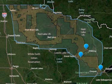
It never ends. Last week, open house meetings began for Minnesota Power’s recently announced Great Northern Transmission Line.
Great Northern? I guess we’re either being railroaded or being sold beans…


Wednesday, November 7th
11:00 am – 1pm
Hermantown Government Services Building, Training Center Room
5105 Maple Grove Road
Hermantown, MN 55811
5:00 pm – 7:00 pm
Sawmill Inn
2301 South Highway 169
Grand Rapids, MN 55744Thursday, November 8th
11:00 am – 1:00 pm
Hibbing Memorial Building Arena, Downstairs Dining Room
400 East 23rd Street
Hibbing, MN 557465:00 – 7:00 pm
Meadowlands Community Center
7758 Western Avenue
Meadowlands, MN 55765
I have a few questions, of course, that’s my job, but first, in Minnesota, transmission corridors are to be used, routes that don’t utilize existing corridors. From an old EQB transmission map, here’s what I’ve got in that general area:

And from an old MAPP map, between Blackberry and Hermantown, two named substations that this line will connect:

Again, this is an old map, and some things have changed…
- one thing that’s clear from the MP map, if you zoom in, or go to google earth, the line going from Cohasset to Blackberry on the north, there are TWO lines in that corridor. Need more info.
- What’s the need claim for this line? The only thing I’ve heard is that they’ve got 250MW coming from Manitoba Hydro.
- What are the conductor specs? The line ratings are here in the MTEP 12 Appendix A, but why a 500kV line for so little MVA (click chart below for larger version)?
 What’s planned for Wisconsin to Michigan? MP and ATC reached a transmission agreement in February: American Transmission Co., Minnesota Power enter into partnership agreement.
- What’s that about a 345 kV line when the MISO MTEP Appendix A says 500 kV (and nominal MVA for a 500 kV line)?
To look at the Certificate of Need docket, go HERE – PUC’S SEARCH DOCKET PAGE and search for docket 12–1163. After you look it up, you can subscribe for notice of future filings by clicking “SUBSCRIBE” and following the directions!
The Notice Plan is up for review:
Minnesota Power’s Notice Plan for Great Northern Transmission Line
This is the plan by which they’ll give people notice about the pending Certificate of Need application, and Comments are due by 4:30 p.m. November 19, 2012, and Reply Comments are due by 4:30 p.m. December 10, 2012. Email comments with “Notice Plan Comments Docket 12-1163” in the subject and body of email to: burl.haar@state.mn.us.
Eye of Hurricane Sandy tracks near Port Penn
October 29th, 2012

The eye of Hurricane Sandy is expected to hit Delaware tonight and run across the state starting about one mile or less from Port Penn, Delaware. That’s where our house is and a little too close for comfort. Port Penn, is a small village, where 9 intersects with Market, around market to the corner where 9 heads south on Congress. We’re just south of Market a block east of where 9 connects. That the little peninsula on the lower right is “Artificial Island” where there are THREE nuclear reactors. Hurricane Sandy is coming in about a mile north of the reactors, and about a mile north of Port Penn. State Rd. 9 is the one that floods all the time and is often closed.
Power outages as of early Monday evening:

Delaware has been declared a disaster area, there’s already lots of flooding and waves coming in over the boardwalk on the southern beaches.
Sandy picks up speed; Obama declares disaster area for Delaware
Power is out north of the canal:
The good news is that the house has been standing since 1742, the historical Steward House, and it’s now got a solidly reinforced new roof (and what a pain in the patoot that was!). But there are a lot of windows pointing towards the Delaware Bay and directly into the oncoming path of hurricane Sandy.


Hope all’s well when we get there in a month or so! Thankfully we’ve got the best neighbors on the planet who will keep us posted.
Delaware — batten the hatches!
October 26th, 2012
Hurricane Sandy on collision course with Mid-Atlantic and Northeast
Here’s NOAA’s trajectory, Delaware’s right in the middle:

Also right in the middle are the nuclear plants:

In Delaware, we’re in Port Penn, right on the Delaware River across from the Salem and Hope Creek nuclear reactors, as it turns into the Delaware Bay. Here’s what it looks like from above, click for larger jpeg, the “A” is Port Penn, the phallic land mass on the right is “Artificial Island” where the plants are, a sand dune out in the bay sucking the little fish into the cooling system:

If the hurricane comes through, right up the Bay, we’re in a world of hurt. It is SO flat there, not at all like the bluffs I’m used to. If you go to google earth, and even on this satellite photo, you can see where the village used to be — it originally was a few blocks out into the water, and Alan thinks that it was a lot lower level than it is now. There were dikes built, using slave labor to build it (Delaware is the south, remains, per Alan, a plantation state), homes were out there on stilts, salt hay growing to feed the animals, and all that is gone but some fragments of the pier pilings. You can see the street next to the water, we’re the second existing street over, so that helps some, but the water level is right up near the surface, the geothermal bubbles up, and septic systems are a nightmare. There are floods regularly, and State Road 9 out of town to the north is often covered in spring, and half covered other times, the roads are frequently closed to the north and south. Here’s coming in to town on State Road 9 from the North (photo from DNREC report below):

This is how it is NOW! If the water level goes up, then what? If there are more storms of higher intensity, then what?
Delaware is a state that is wisely planning for rising sea level:
… and here’s their plan:
Preparing for Tomorrow’s High Tide: Sea Level Rise Vulnerability Assessment for the State of Delaware Published July 30, 2012
I checked, did a search, and “nuclear” is not mentioned. Ummmmm… hello? Remember the Ft. Calhoun nuclear plant (extra credit if you know anything about the Ft. Calhoun interface!)?
