Delaware prepares for sea level rise
May 24th, 2013
Yesterday was a meeting of the Delaware Sea Level Rise Advisory Committee at Kitts Hummock, by Dover. Their charge is broad:
“…potential solutions to reduce risk to sea level rise impacts…” but they’re missing the boat in at least one obvious area…
The reality of sea level rise is apparent every time I head up to Delaware City, because Route 9 is underwater, from 1/3 to 2/3 of the southbound lane. When we headed to Kitts Hummuck (what’s a hummuck? “It’s like a tussock, but bigger,” Alan says.) and there was water on Route 9 south of Port Penn, too. Delaware is SO flat, and Port Penn’s development has moved back from water’s edge:

In looking at the draft report, the first thing I noticed was that there was nothing about preparation about how sea level rise would affect utility infrastructure (the love of my life!). During a break, the DOT rep at the meeting let me know that they’d done a “Vulnerability Study” that addresses that, and here it is:
.. and no, there’s nothing about electrical infrastructure, ranging from generation, to transmission, to distribution. A search shows only one reference to electrical:
Data Collection
In order to conduct an in-depth vulnerability assessment, geographic datasets are necessary. Geographic datasets are a special type of dataset that contains information so that it can be placed on a map. Delaware Coastal Programs staff spent considerable time and effort compiling geographic datasets that could be utilized
with the sea level rise scenario maps to determine the location and numbers of resources at risk from sea
level rise. Datasets like roads, railways and public safety facilities were relatively easy to obtain as they are
maintained and routinely updated by a state or county agency. Many datasets were out of date or lacked
appropriate documentation as to when the data was collected or how it was collected (metadata). A few
datasets were unable to be used for this assessment due to privacy or homeland security concerns (electrical
substations for example). In many other cases, the desired data did not exist or was so out of date that it could
not be used.
Oh my… ummmmmmm… what a bunch ‘o crap! They need to look at this stuff, and for sure they have access. They are a government entity doing planning. EARTH TO MARS — all they have to do is sign a form, and if they don’t want to do that, they can look at google maps. THERE IS NO EXCUSE FOR THIS.
Why does it matter whether they consider electrical infrastructure? Well, electricity is deemed an essential service, and if it’s underwater, they’re gonna have problems, to put it mildly. Power plants are typically located on water, Indian River is a perfect example, sited on the Indian River Bay, just off the ocean, and about a foot above the water level:

What do they say about the Indian River power plant? This is it:
The Indian River power plant is the only heavy industrial facility permitted by the Coastal Zone Act in Sussex
County. This facility’s disposal area, shoreline, and intake structures are within areas that will be inundated by sea level rise, but the power plant itself is not within a potential inundation area.
Otherwise, power plants are addressed only in terms of impact of loss of rail service. Great…
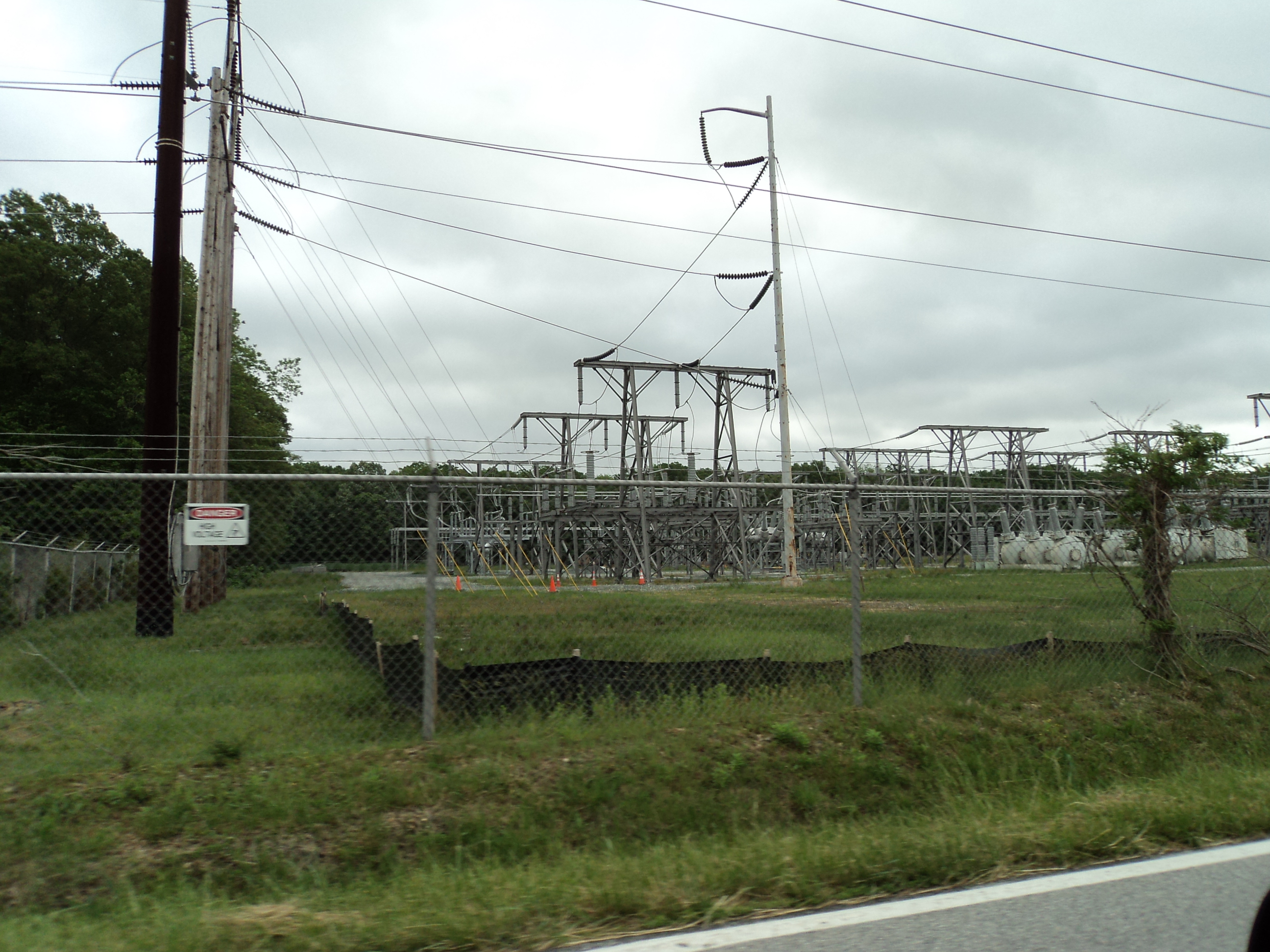
Here’s a photo I took of one of the substations they’re ignoring — took this photo while flying by on Route 9, close to Kitts Hummock. I saw this substation, there’s no reason they can’t, and when this substation goes underwater, then what? A state with homes as old as ours should have an understanding of long-term planning (it looks to me that this was built in anticipation of MAPP, it’s huge and has a lot of empty positions:
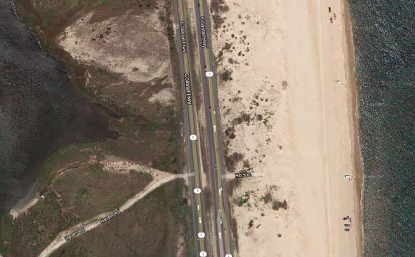
The only transmission considered is disease transmission. An example of transmission facilities at issue is the one along Hwy. 1, by Indian River, pictured here where the Bay is on the west (left), the transmission line is immediately adjacent to the southbound lane of Hwy. 1, and the ocean is east of Hwy. 1:
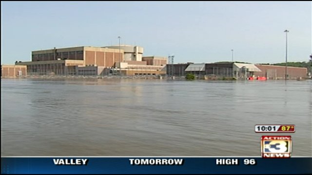
Nuclear is not mentioned, despite the three reactor Salem and Hope Creek plant just across the Delaware Bay. With sea level rise, it will soon look like Ft. Calhoun:
Here’s what they have to say about pipelines, p. 101 of Vulnerability Assessment — they’re not concerned:
Underground Pipeline Utilities: This resource includes natural gas and petroleum pipelines. Workgroup
members also initially considered water and sewer pipelines; however, data was unavailable due to privacy and homeland security concerns. Between 4% and 6% of pipeline utilities throughout the state are within an area that could be inundated by sea level rise by the year 2100. While sections of pipeline are exposed in all three counties, the highest concentration is found in New Castle County. The results from the analysis showed that major supply lines will not be affected; however, distribution along with pipeline corrosion may become issues in the future. Due to these considerations, inundation of underground pipeline utilities is of low concern at this time.
Despite the significant omissions, look at all the Delaware organizations that supported it:
Anyway, then yesterday, they approved the recommendations, with a few minor changes. And those recommendations are not posted — the most recent minutes are from March… sigh…
So rough and quick and dirty review of what they did:
- Approved the lion’s share of the recommendations;
- Deleted #17, which was focused on financial assurance to minimize the state’s liability. GRRRRRR!
- Approved #35 which shifts the burden of notice/disclosure to a home buyer, rather than on a seller and/or realtor. This is SO WRONG!
- Sussex County rep was worthless, sat there silently except to abstain from voting. ?????
From the News Journal:
Saving Delaware’s coast from sea-level rise
Sussex declines to vote on proposed sea-level rise responses
Buy the Farm bolstered, at long last
May 22nd, 2013
WOW, what a long strange trip this has been. I’ve been on this since Chisago I (1996) and Arrowhead:
Arrowhead was exempted, and hence Buy the Farm doesn’t apply, so that went to the Appellate Court, which tossed it out. And the 2001 statutory changes, which defined “high voltage transmission lines” as anything over 100 kV, meaning Buy the Farm would apply to 115 kV lines like SE Metro, and Chisago, but nooooo, can’t have that, so Sen. Metzen then amended in 2002 so that it only applies to lines 200 kV or over. GRRRRRRRRRRRR.
Here’s the update in the Belle Plaine Herald (why is there nothing whatsoever in the STrib?). GRE’s Randy Fordice claims it’s vaguely worded, but I think it’s pretty specific:
All rights and protections provided to an owner under chapter 117 apply to acquisition of land or an interest in land under this section.
DOH! Vague my ass…
|
|
|
Our neighbor Lake has died…
May 22nd, 2013

It’s a sad day in Red Wing and in Port Penn this morning. Our neighbor Lake, who I’ve known since he was six months old, has died.
When I met him, I was down in the street in front of the house, and he and his human, Barry, came trotting down the street. He was just a pup, and at 6 months was the size of my Katze, a year and a half old shepherd, and he was 20 pounds heavier already! He was your typical lab pup, full of energy. He and Katze would leap up the two retaining walls up to the house, run behind the house and around a few times, jump down, and repeat, and repeat, and repeat. You could hear their peals of laughter and joy in being dogs. Did I mention he was full of energy? My other dogs weren’t as good to him, frankly, they were bitches, but Lake, lab that he is, was a gentleman always.
When I’d visit the Moens, he’d always cozy up to me, maybe smelling the treats in my pocket, or maybe just enjoying my “Eau de Shep,” and his BIG head would always rest on my knee, trusting. He was the kind of dog you couldn’t resist hugging, who would make a good bedwarmer on a cold Minnesota night.
Poor dear didn’t do too well when I took care of him not that long ago, he drank and drank and made himself sick, WOW, his belly held a lot!!! He recovered quickly, ready to eat more, OK, fine, Lake, but no more water!!!!
He’d been visibly slowing down, trudging along 8th Street, not wanting to run up the bluff, and recently it got to where he couldn’t do stairs (see photo, that’s a real problem) or go for walks. Then he quit eating, where even beef and rice had no appeal. The photo of him was his last morning, surveying his kingdom in Red Wing.
Lake, we’ll miss you, good neighbor!!! Give my regards to our grrrrrrrrrrls Katze, Krie, Kenya and Summer who are there to meet you and show you the ropes… and bones, and venison steaks, and running paths!
Whew! Linda & Matt did it — wedding’s done!
May 18th, 2013
Got to Delaware just in time — Matt and Linda got married today. As Alan says, it’s good they can be together for 18 years and still want to get married! THEY DID IT!

They’re my favorite people in Delaware, well, except for Alan of course, and Matt’s mother makes pizelles to die for! Matt and Linda run DelPizzo Construction:

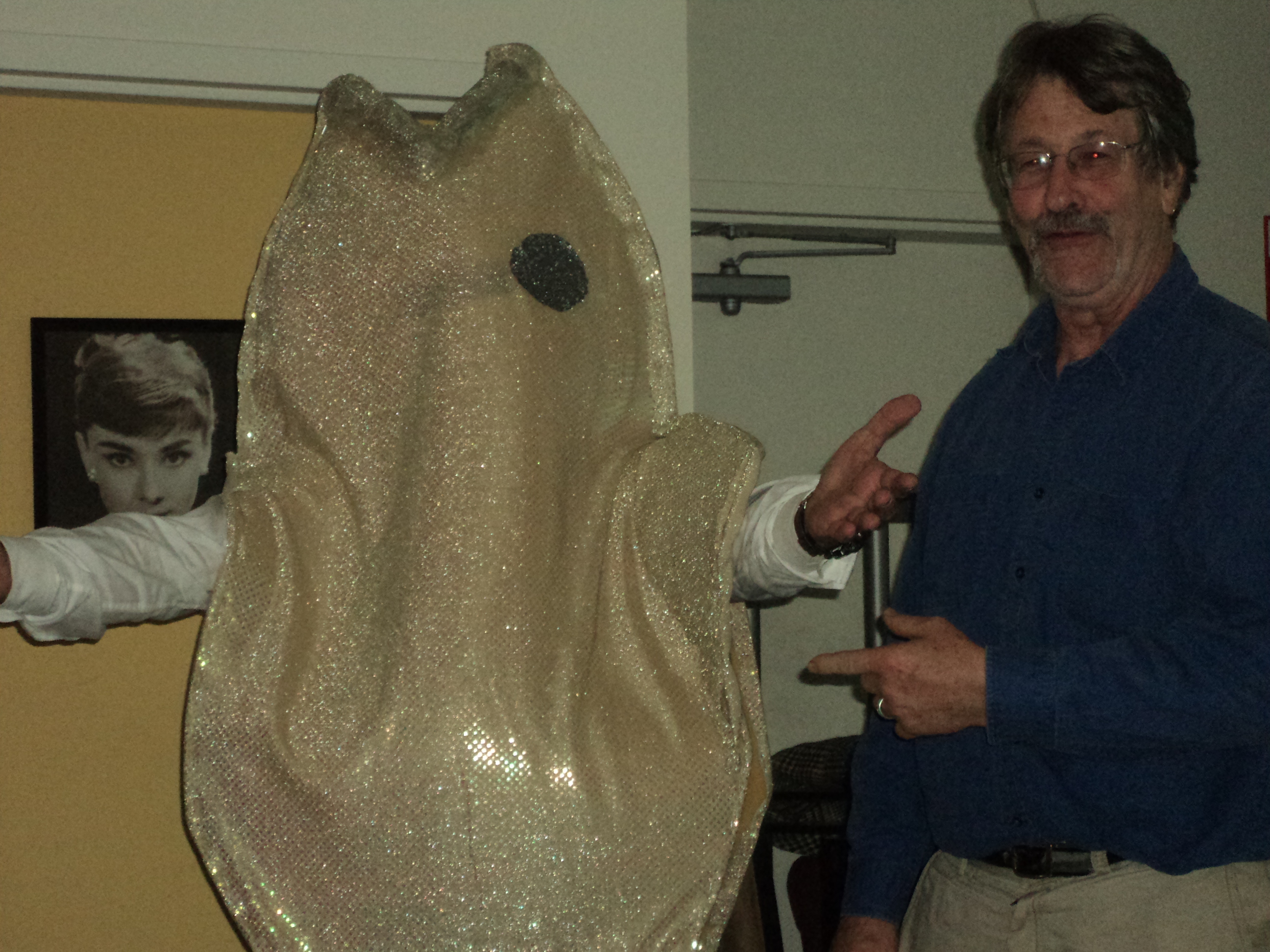
Linda and Matt are both are active environmentalists, Matt has been a primary part of Delaware Audubon for ages and they did the heavy lifting last year when Audubon gave Alan its environmental award. Linda has amazing artistic talents, making Alan a beautiful 6 foot bright blue sequin fish costume for a hearing, and for a demonstration in Dover, flat black cut-outs, a water buffalo/pig (?) representing former Gov. Minner connected by chains and led around by the nose by a big bankster! That’s Matt in the tan fish outfit at the Delaware AudubonFest:
As weddings go, it was as good as it gets (well, I’m not a big fan, don’t cha know), haven’t been to a wedding in SO long… and, well, I’ve got an aversion to this day, May 18 is my anniversary, 39 years ago — I told Linda about that and she noted that she was 6 months old then. SAY WHAT! Whoa, talk about feeling like an old fart, we’re as old as their parents — I had no idea! Anyway, for them, and to get some long overdue work done in DE, we hit the road. It was in historic Odessa, Delaware, at the Corbit-Sharp House, really a complex of historic houses and a great barn for serving. Appetizers (veggies, fruit, cheeze, bread) and sufficient ETOH to be lubricated prior to the show, a short and sweet ceremony, and on to dinner, mostly vegan, PIZELLES and the Rock Fish with Chimichurri Sauce, oh so good, the Cantwell’s Tavern did the food. And PIZELLES! Vegan wedding cake of carrot and pineapple (coconut and ??? frosting, maybe soy milk or soy cream cheeze?). Have to admit, I skipped the cigar bar… and did I mention PIZELLES???!!!???
A few weeks ago when Matt was in Minnesota on an Anderson Windows junket, we corralled him for dinner, he sacrificed a tour in the pole-dancer bus, and it was clear how much he was missing Linda (well, that’s Alan and my guess anyway), they’re one of the few couples I know who are a joy to be around together. So after 18 years, here they go, married – ’bout time!
CONGRATULATIONS, Matt & Linda!
Goodhue Wind winds down… slowly…
May 14th, 2013
A little birdie tells me that my site is a snooze.

That’s true. I’ve been getting some domestic projects done that I’ve been ignoring, and I’ve started a big project that requires lots of research… zzzzzzzzzzzzzzzzzzzzzzzzzz… believe me, that’s more of a snooze than my blog, and I hope worth the wait.
So what else is happening?
The Goodhue Wind project was taken off the May 2 Public Utilities Commission agenda and “temporarily” rescheduled for June 20, 2013. But there’s a new filing provided by Xcel Energy that got me snortin’ recently, dig this:
And no hints – you’ve got to read the whole thing. Peter Mastic is more than a little bruised after this letter!