Life on the Mississippi!
October 26th, 2015
![20151026_130812[1]](https://legalectric.org/f/2015/10/20151026_1308121.jpg)
Couldn’t be a better place to office on this beautiful fall day, but… ENOUGH WORK! LATER!

St. Louis area landfill burning near nuclear waste
October 23rd, 2015
This has been in the news a lot lately due to the Missouri Attorney General’s release of reports that are part of a lawsuit against the owners of the landfill, Republic Services, which, the AG states has “poisoned its neighbors’ groundwater and vegetation.” Great… just great… What I get out of this is that the fire’s movement towards the nuclear waste is a concern, but there are already significant problems in the here and now to deal with.
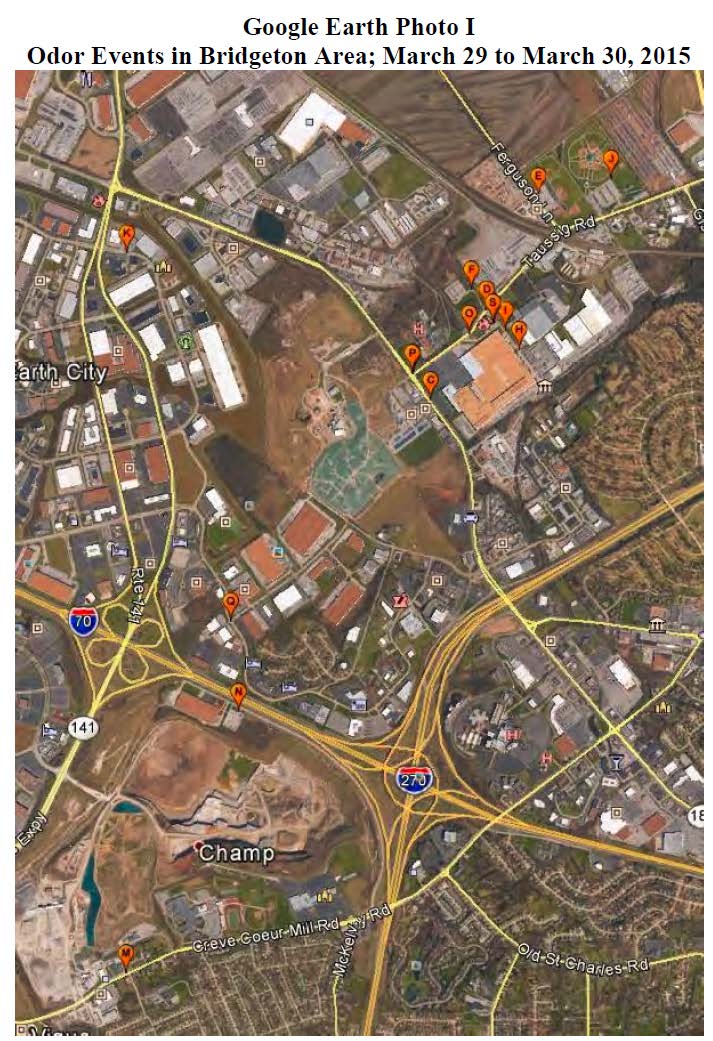
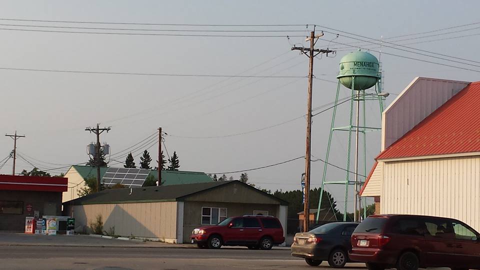
Site Q on the map above is right by the Candlewood Inn hotel that I stay at during BaronFest, held at the home of a friend in Maryland Heights just south of the bottom center of this map. Here’s Kady, settled into the hotel:

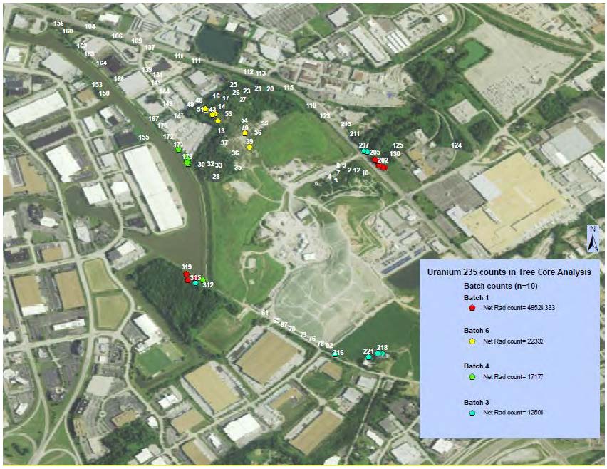
The reports released are pretty disturbing. Here are some maps from the Westlake Landfill Tree Core Analysis – Burken/Usman showing elevated U-235 in tree core samples:
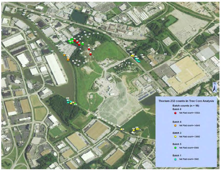
And here’s a similar map for Thorium, but note this concentration is to the north:
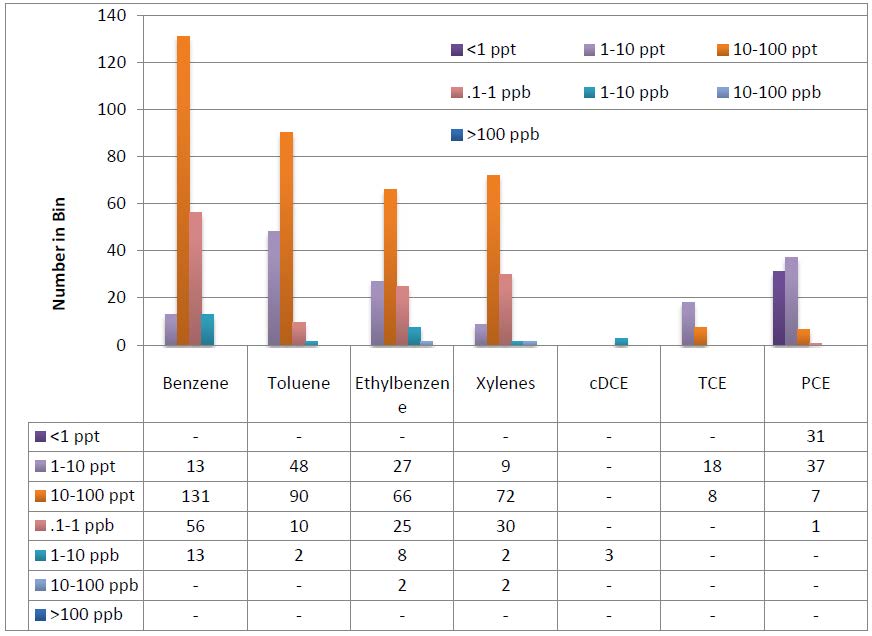
And from the same report, check out these carcinogens in the core samples:
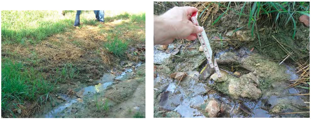
And from the Field Inspection Reports – Stark, visible leachate outbreak — it’s clearly not contained:
The primary documents from the Missouri Attorney General’s site:
- West Lake Landfill Organic Pollutant Phytoforensic Assessment – Burken
- Westlake Landfill Phytoforensic Assessment using Gamma Spectroscopy – Usman
- Westlake Landfill Tree Core Analysis – Burken/Usman
- Bridgeton Sanitary Landfill Groundwater Investigation – Price/Wronkiewicz
- Subsurface Self Sustaining Reaction Incident – Sperling/Abedini
- Bridgeton Sanitary Landfill Incident – Thalhamer
- Field Inspection Reports – Stark
- Bridgeton Landfill Downwind Odor Assessment – Wright
- Feasibility Study – Groundwater Remediation – Hemmen
Menahga Xmsn in the Park Rapids Enterprise
October 21st, 2015
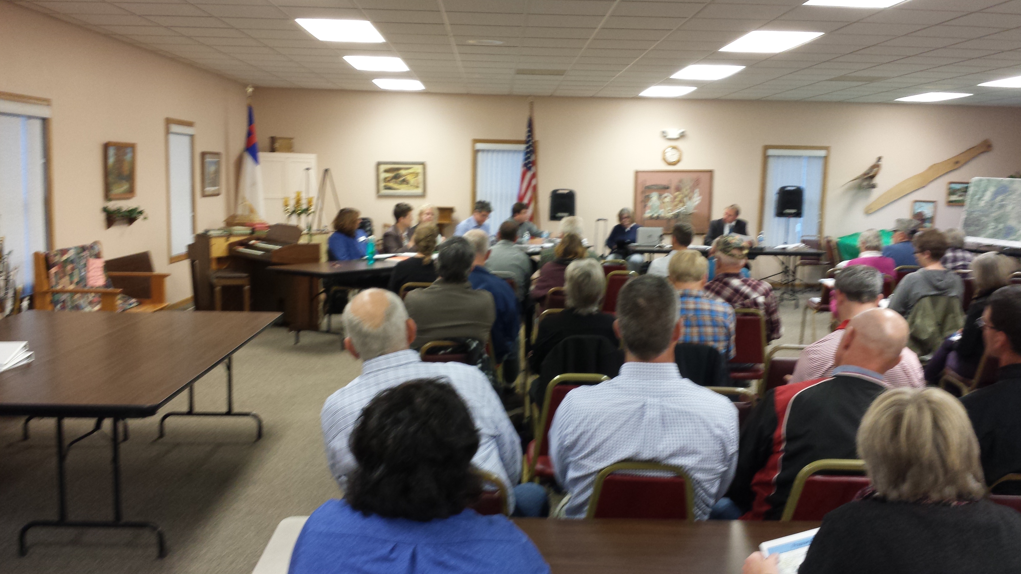
Monday’s hearing in Menahga got a thorough report in the Park Rapids Enterprise. Now, will the Administrative Law Judge and the Public Utilities Commission pay as much attention?
And a little correction, “Pipeline” should be “Powerline” in the 3rd paragraph. As newspaper articles go, this is as good as it gets! Lots of detail. And the need part, the “Carol Overland question” is there in black and white.
To see the full Public Utilities Commission dockets, go to the PUC’s SEARCH DOCKET PAGE HERE, and search for dockets 14-787 (Certificate of Need) and 14-797 (Route Permit).
And in the Park Rapids Enterprise:
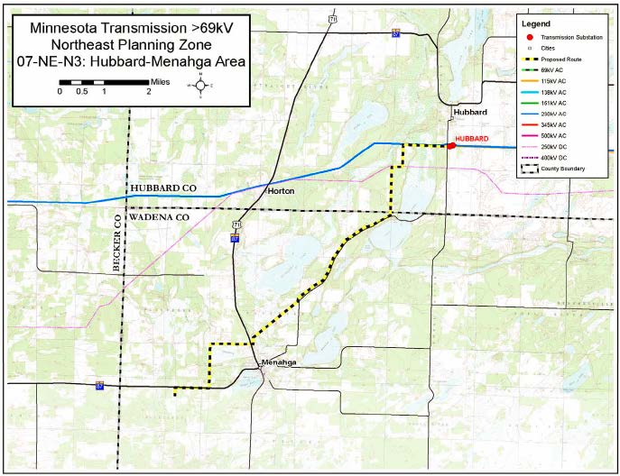
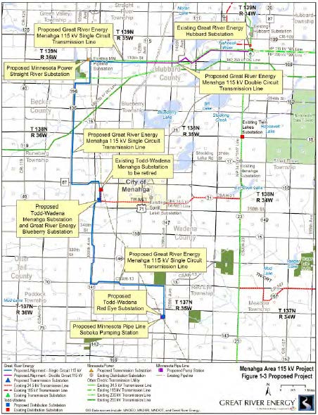
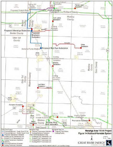
Hearing held in Menahga to discuss proposed transmission lines
- An east-west section between the existing GRE Hubbard Substation and the proposed MP Straight River Substation. Four and a half miles would be double circuit 115 kV lines and 2.5 miles would be single circuit lines.
- A north-south section of single-circuit lines, around 15.5 miles, would run between the proposed MP Straight River Substation and the proposed Red Eye distribution substation.
- A proposed new MP Straight River Substation, GRE Blueberry Substation and Todd-Wadena Red Eye Substation; relocation of Todd-Wadena’s existing Menahga distribution substation to the Blueberry site and converting the voltage from 34,5 kV to 115 kV. There would also be modifications to the existing MP Pipeline Substation and GRE Hubbard Substations.
Menahga Transmission Project hearing
October 21st, 2015

Tonight was the public hearing for the Menahga Transmission Project. This is A transmission project with a pipeline driver.
This is a weird project. They’re admittedly having problems with the old 34.5 kV distribution system, that was established ages ago in the GRE_Long Range Xmsn Plan_October 2008, and in the last four Biennial Transmission Plans (their application claimed that “this project” had been under discussion since 2007 as project “2007-NE-N3”):
2007-NE-N3_2007 Biennial Transmission Plan
2007-NE-N3_2009 Biennial Transmission Plan
2007-NE-N3_2011 Biennial Transmission Plan
2007-NE-N3_2013 Biennial Transmission Plan where it morphed into “2014-NE-N21”
Check the 2007 map for project 2007-NE-N3:
Does that bear any resemblance to the project they applied for:
Nope, there’s no resemblance, I didn’t think so either.
But I did find this interesting map of the “project area” that shows the 2007 area in question and more easily shows the logic behind their claim that:
There’s that green line right down the middle that’s the focus of the “problems” claimed. And from that 2007 report:
The Hubbard-Menahga 115 kV line would be the start of a Hubbard-Menahga-Wadena/Compton-Wing River 115 kV line.
Walk through that list of cities, and you don’t get anything that looks like what they proposed. It does indeed look a lot like fixing that green line that connects all the cities would answer their problems!
In the hearing, I clarified the capacity of the line, which at 140 is 7 times that needed for their 20 MW load (click for larger chart). Go to the 477 on left side (kcmil) and then scoot over to the “115” column in the MVA rating columns on the right, scroll down to the “140.” As the engineer confirmed, the 140 MVA is essentially MW…
And here’s the peak demand for the entire area, 16.48 MW, for which they’re wanting a 140 MVA capacity line:
Why?
Oh, well, there is that pipeline driver, the MinnCan pipeline over to the Koch refinery, and they want more pumping stations to increase the capacity from 165,000 barrels a day to 350,000 barrels a day. And they want to double circuit the part on the northern end, from Hubbard substation to somewhere west of that for a “future GRE project” that they will not identify further, but they did not deny that it was Sandpiper (and $50 says it is).
The good news is that there’s tofu in the neighborhood for fortification, should get three meals out of this!

LTE: Thanks, City Council, for Reconsideration
October 19th, 2015
And the Republican-bEagle here in Red Wing published my Letter to the Editor, here it is online:
Letter: Thanks, City Council, for reconsideration