Mankato-Mississippi Xmsn FEIS released
July 25th, 2025
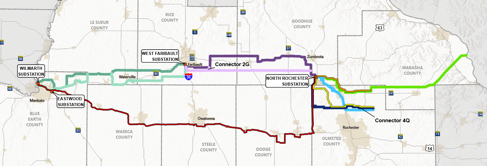
Short version:
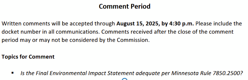

It took Commerce-EERA two days to upload all of this — 867 pages of the Narrative [row 78 below), 127 filings. My eyes are crossing just trying to get it posted here. Methinks an extension of Comment period would help! [p.s. I cannot figure out how to get rid of that far right column… hmmmm, a common problem these days!]
| 1 | 20257-221382-01 | FEIS – Map 21 Segment 2 NLCD | |
| 2 | 20257-221382-02 | FEIS – Map 22 Segment 2 Water Resources | |
| 3 | 20257-221382-03 | FEIS – Map 23 Segment 2 Recreation Resources Mapbook | |
| 4 | 20257-221382-04 | FEIS – Map 24 Segment 2 Ecological Classification System | |
| 5 | 20257-221382-05 | FEIS – Map 25 Segment 2 Existing Infrastructure | |
| 6 | 20257-221382-06 | FEIS – Map 26 Segment 2 Detailed Map Book Part 1 | |
| 7 | 20257-221382-07 | FEIS – Map 26 Segment 2 Detailed Map Book Part 2 | |
| 8 | 20257-221382-08 | FEIS – Map 26 Segment 2 Detailed Map Book Part 3 | |
| 9 | 20257-221382-09 | FEIS – Map 26 Segment 2 Detailed Map Book Part 4 | |
| 10 | 20257-221382-10 | FEIS – Map 26 Segment 2 Detailed Map Book Part 5 | |
| 11 | 20257-221382-11 | FEIS – Map 26 Segment 2 Detailed Map Book Part 6 | |
| 12 | 20257-221382-12 | FEIS – Map 26 Segment 2 Detailed Map Book Part 7 | |
| 13 | 20257-221382-13 | FEIS – Map 27 Segment 2 Zoning | |
| 14 | 20257-221382-14 | FEIS – Map 28 Segment 2 Residences and Structures | |
| 15 | 20257-221382-15 | FEIS – Map 29 Segment 2 Prime Farmland | |
| 16 | 20257-221382-16 | FEIS – Map 30 Segment 2 Cultural Resources | |
| 17 | 20257-221382-17 | FEIS – Map 31 Segment 2 Sensitive Ecological Resources | |
| 18 | 20257-221382-18 | FEIS – Map 32 Segment 2 Surface Soil Texture | |
| 19 | 20257-221382-19 | FEIS – Map 33 Segment 2 Wildlife Resources | |
| 20 | 20257-221382-20 | FEIS – Map 34 Route Segment 17 (Highway 14 Option) NLCD | |
| 21 | 20257-221382-21 | FEIS – Map 35 Route Segment 17 (Highway 14 Option) Water Resources | |
| 22 | 20257-221382-22 | FEIS – Map 36 Route Segment 17 (Highway 14 Option) Recreation Resources | |
| 23 | 20257-221382-23 | FEIS – Map 37 Route Segment 17 (Highway 14 Option) Ecological Classification System | |
| 24 | 20257-221382-24 | FEIS – Map 38 Route Segment 17 (Highway 14 Option) Existing Infrastructure | |
| 25 | 20257-221382-25 | FEIS – Map 39 Route Segment 17 (Highway 14 Option) Detailed Map Book Part 1 | |
| 26 | 20257-221382-26 | FEIS – Map 39 Route Segment 17 (Highway 14 Option) Detailed Map Book Part 2 | |
| 30 | 20257-221382-30 | FEIS – Map 39 Route Segment 17 (Highway 14 Option) Detailed Map Book Part 6 | |
| 32 | 20257-221382-32 | FEIS – Map 39 Route Segment 17 (Highway 14 Option) Detailed Map Book Part 8 | |
| 33 | 20257-221382-33 | FEIS – Map 39 Route Segment 17 (Highway 14 Option) Detailed Map Book Part 9 | |
| 34 | 20257-221382-34 | FEIS – Map 40 Route Segment 17 (Highway 14 Option) Zoning | |
| 35 | 20257-221382-35 | FEIS – Map 41 Route Segment 17 (Highway 14 Option) Residences and Structures | |
| 36 | 20257-221382-36 | FEIS – Map 42 Route Segment 17 (Highway 14 Option) Prime Farmland | |
| 37 | 20257-221382-37 | FEIS – Map 43 Route Segment 17 (Highway 14 Option) Cultural Resources | |
| 40 | 20257-221382-40 | FEIS – Map 46 Route Segment 17 (Highway 14 Option) Wildlife Resources | |
| 41 | 20257-221382-41 | FEIS – Map 47 Segment 1 and 2 Route Options | |
| 42 | 20257-221383-01 | FEIS – Map 48 Segment 3 NLCD | |
| 43 | 20257-221383-02 | FEIS – Map 49 Segment 3 Water Resources | |
| 44 | 20257-221383-03 | FEIS – Map 50 Segment 3 Recreation Resources | |
| 45 | 20257-221383-04 | FEIS – Map 51 Segment 3 Ecological Classification System | |
| 46 | 20257-221383-05 | FEIS – Map 52 Segment 3 Existing Infrastructure | |
| 47 | 20257-221383-06 | FEIS – Map 53 Segment 3 Detailed Map Book | |
| 48 | 20257-221383-07 | FEIS – Map 54 Segment 3 Zoning | |
| 49 | 20257-221383-08 | FEIS – Map 55 Segment 3 Residences and Structures | |
| 50 | 20257-221383-09 | FEIS – Map 56 Segment 3 Prime Farmland | |
| 51 | 20257-221383-10 | FEIS – Map 57 Segment 3 Cultural Resources | |
| 52 | 20257-221383-11 | FEIS – Map 58 Segment 3 Sensitive Ecological Resources | |
| 53 | 20257-221383-12 | FEIS – Map 59 Segment 3 Surface Soil Texture | |
| 54 | 20257-221383-13 | FEIS – Map 60 Segment 3 Wildlife Resources | |
| 55 | 20257-221384-01 | FEIS – Map 61 Segment 4 NLCD | |
| 56 | 20257-221384-02 | FEIS – Map 62 Segment 4 Water Resources | |
| 57 | 20257-221384-03 | FEIS – Map 63 Segment 4 Recreation Resources | |
| 58 | 20257-221384-04 | FEIS – Map 64 Segment 4 Ecological Classification System | |
| 59 | 20257-221384-05 | FEIS – Map 65 Segment 4 Existing Infrastructure | |
| 60 | 20257-221384-06 | FEIS – Map 66 Segment 4 Detailed Map Book Part 1 | |
| 61 | 20257-221384-07 | FEIS – Map 66 Segment 4 Detailed Map Book Part 2 | |
| 62 | 20257-221384-08 | FEIS – Map 66 Segment 4 Detailed Map Book Part 3 | |
| 63 | 20257-221384-09 | FEIS – Map 66 Segment 4 Detailed Map Book Part 4 | |
| 64 | 20257-221384-10 | FEIS – Map 66 Segment 4 Detailed Map Book Part 5 | |
| 65 | 20257-221384-11 | FEIS – Map 66 Segment 4 Detailed Map Book Part 6 | |
| 66 | 20257-221384-12 | FEIS – Map 66 Segment 4 Detailed Map Book Part 7 | |
| 67 | 20257-221384-13 | FEIS – Map 66 Segment 4 Detailed Map Book Part 8 | |
| 68 | 20257-221384-14 | FEIS – Map 67 Segment 4 Zoning | |
| 69 | 20257-221384-15 | FEIS – Map 68 Segment 4 Residences and Structures | |
| 70 | 20257-221384-16 | FEIS – Map 69 Segment 4 Prime Farmland | |
| 71 | 20257-221384-17 | FEIS – Map 70 Segment 4 Cultural Resources | |
| 72 | 20257-221384-18 | FEIS – Map 71 Segment 4 Sensitive Ecological Resources | |
| 73 | 20257-221384-19 | FEIS – Map 72 Segment 4 Surface Soil Texture | |
| 74 | 20257-221384-20 | FEIS – Map 73 Segment 4 Wildlife Resources | |
| 75 | 20257-221384-21 | FEIS – Map 74 Segment 4 Route Options |
| 78 | 20257-221369-01 | Final Environmental Impact Statement – Narrative | |
| 79 | 20257-221369-02 | FEIS – Appendix A DEIS Comments and Responses | |
| 80 | 20257-221369-03 | FEIS – Appendix B Scoping Decision Part 1 | |
| 81 | 20257-221369-04 | FEIS – Appendix B Scoping Decision Part 2 | |
| 82 | 20257-221375-01 | FEIS – Appendix B Scoping Decision Part 4 | |
| 83 | 20257-221375-02 | FEIS – Appendix B Scoping Decision Part 3 | |
| 84 | 20257-221375-03 | Appendix C – Spatial Data | |
| 85 | 20257-221375-04 | Appendix D – Alternatives Summary | |
| 86 | 20257-221375-05 | Appendix E – Supplemental Information Inquiry Responses | |
| 87 | 20257-221375-06 | Appendix F – MnDOT Correspondence | |
| 88 | 20257-221375-07 | Appendix G – Data Analysis Tables | |
| 89 | 20257-221375-08 | Appendix H – Sample Route Permit | |
| 90 | 20257-221375-09 | Appendix I – Property Values Supplement | |
| 91 | 20257-221375-10 | Appendix J – Electric and Magnetic Fields Supplement | |
| 92 | 20257-221375-11 | Appendix J – Agricultural Impact Mitigation Plan | |
| 93 | 20257-221375-12 | Appendix L – Greenhouse Gas Calculations | |
| 94 | 20257-221375-13 | Appendix M – Threatened and Endangered Species | |
| 95 | 20257-221376-01 | FEIS – Map 1 Applicant Proposed Segments | |
| 96 | 20257-221376-02 | FEIS – Map 2 Project Overview | |
| 97 | 20257-221376-03 | FEIS – Map 3 Segment 1 ROW Sharing and Paralleling | |
| 98 | 20257-221376-04 | FEIS – Map 4 Segment 2 ROW Sharing and Paralleling | |
| 99 | 20257-221376-05 | FEIS – Map 5 Highway 14 ROW Sharing and Paralleling | |
| 100 | 20257-221376-06 | FEIS – Map 6 Segment 3 ROW Sharing and Paralleling | |
| 101 | 20257-221376-07 | FEIS – Map 7 Segment 3 ROW Sharing and Paralleling | |
| 102 | 20257-221376-08 | FEIS – Map 8 Segment 1 NLCD | |
| 103 | 20257-221376-09 | FEIS – Map 9 Segment 1 Water Resources | |
| 104 | 20257-221376-10 | FEIS – Map 10 Segment 1 Recreation Resources Mapbook | |
| 105 | 20257-221376-11 | FEIS – Map 11 Segment 1 Ecological Classification System | |
| 106 | 20257-221376-12 | FEIS – Map 12 Segment 1 Existing Infrastructure | |
| 107 | 20257-221376-13 | FEIS – Map 13 Segment 1 Detailed Map Book – Part 1 | |
| 108 | 20257-221376-14 | FEIS – Map 13 Segment 1 Detailed Map Book – Part 2 | |
| 109 | 20257-221376-15 | FEIS – Map 13 Segment 1 Detailed Map Book – Part 3 | |
| 110 | 20257-221376-16 | FEIS – Map 13 Segment 1 Detailed Map Book – Part 4 | |
| 111 | 20257-221376-17 | FEIS – Map 13 Segment 1 Detailed Map Book – Part 5 | |
| 112 | 20257-221376-18 | FEIS – Map 13 Segment 1 Detailed Map Book – Part 6 | |
| 113 | 20257-221376-19 | FEIS – Map 13 Segment 1 Detailed Map Book – Part 7 | |
| 114 | 20257-221376-20 | FEIS – Map 13 Segment 1 Detailed Map Book – Part 8 | |
| 115 | 20257-221376-21 | FEIS – Map 13 Segment 1 Detailed Map Book – Part 9 | |
| 116 | 20257-221376-22 | FEIS – Map 13 Segment 1 Detailed Map Book – Part 10 | |
| 117 | 20257-221376-23 | FEIS – Map 13 Segment 1 Detailed Map Book – Part 11 | |
| 118 | 20257-221376-24 | FEIS – Map 13 Segment 1 Detailed Map Book – Part 12 | |
| 119 | 20257-221376-25 | FEIS – Map 13 Segment 1 Detailed Map Book – Part 13 | |
| 120 | 20257-221376-26 | FEIS – Map 13 Segment 1 Detailed Map Book – Part 14 | |
| 121 | 20257-221376-27 | FEIS – Map 14 Segment 1 Zoning | |
| 122 | 20257-221376-28 | FEIS – Map 15 Segment 1 Residences and Structures | |
| 123 | 20257-221376-29 | FEIS – Map 16 Segment 1 Prime Farmland | |
| 124 | 20257-221376-30 | FEIS – Map 17 Segment 1 Cultural Resources | |
| 125 | 20257-221376-31 | FEIS – Map 18 Segment 1 Sensitive Ecological Resources | |
| 126 | 20257-221376-32 | FEIS – Map 19 Segment 1 Surface Soil Texture | |
| 127 | 20257-221376-33 | FEIS – Map 20 Segment 1 Wildlife Resources | |
$4.9 BILLION for Grain Belt Xmsn gone!
July 25th, 2025
Trump administration canceled a $4.9B loan guarantee for a line to deliver green power
The good news is they’ve lost federal funding, but it’s been withdrawn for all the wrong reasons. The Trump administration has pulled out of financing due to their hate on of all things greenie-weenie.
So the next logical question is what other transmission projects have had their federal grants and/or loans cut?
Cannon Falls Data Center AUAR
July 22nd, 2025
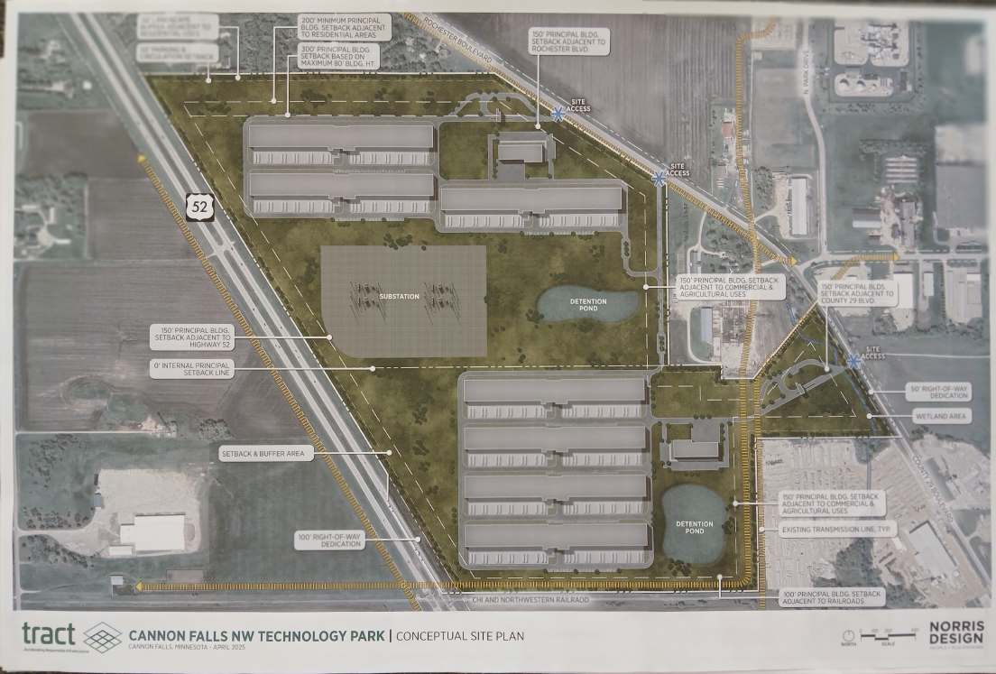
Today the AUAR for the Cannon Falls data center was published in the EQB Monitor:
Cannon Falls Industrial AUAR
Scroll down to find the link to the “Revised AUAR” and here it is, all 216mb (I’m trying to reduce it, will probably have to break it up):
Comments are separated out, Comments are in Appendix H, pps. 380 to the end at 454, and their responses precede that in Appendix G.
And I have to admit, I had a little fun with them in an afterthought, in addition to ripping the AUAR in specificity:
Report on Immigration Detention in Florida
July 21st, 2025
In case the links don’t work in the pdf, here’s a direct link — it’s important because this report does a thorough job of documentation:
“You Feel Like Your Life is Over”
Abusive Practices at Three Florida Immigration
Detention Centers Since January 2025
Talon’s Tamarack EAW filed, DNR version next
July 16th, 2025
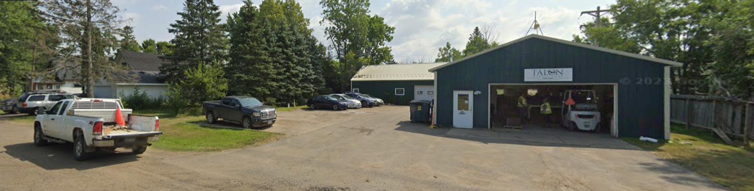
Talon has filed it’s version of the Tamarack Mining Project EAW, and what happens next is the DNR takes that, reviews and revises it, makes it more complete hopefully, and THEN it’s open for public comment.
It’s confusing, the MN Dept. of Natural Resources permitting and environmental review process when compared with the Public Utilities Commission’s process that I’m steeped in. I had to check with the DNR as it made no sense to me. So I asked around, I did, and got this response with these details:
The DNR’s webpage is up to date; the proposed Tamarack Mining Project is currently early in the scoping phase of the environmental impact statement (EIS) process. The June 23rd environmental assessment worksheet (EAW) document you referenced is an EAW data submission by Talon Nickel. During EIS scoping, the DNR requests that the project proposer (Talon Nickel) submit information to the DNR in the EAW form; we call these “data submittals”. The DNR reviews the data submittal for completeness and if incomplete, returns the EAW data submittal for corrections along with comments. You can view the DNR’s comments from previous EAW data submittals on the DNR’s Tamarack Mining Project webpage under the Other DNR documents section. This step can include several rounds of back and forth between the DNR and the project proposer to obtain the necessary information.
While the EAW data submittals are available for the public to view, they are not open to public comment. Once the DNR determines that the EAW data submittal is complete, the DNR will develop and publish a DNR-version of the EAW, called a scoping EAW, along with a draft scoping decision document (containing the proposed scope of the EIS) for public review and comment for a minimum of 30 days. The public review period will also include at least one public meeting. These documents will be formally noticed in the EQB Monitor and published on the DNR’s Tamarack Mining Project webpage under the Scoping EAW and draft scoping decision document section.
The March 20th Lands and Minerals news release you referenced is regarding an exploration plan that Talon Nickel submitted to the DNR to continue nonferrous mineral exploration on state leases in Aitkin and Carlton counties. This exploration plan is different than Talon Nickel’s proposed Tamarack Mining Project that is currently undergoing environmental review (described in the previous two paragraphs).
To be kept informed of the environmental review process for the proposed Tamarack Mining Project, I suggest signing up for email updates. By signing up you will receive updates on any new environmental review project documents available for public viewing, quarterly updates, and notice of formal comment periods. General information about the state’s environmental review process can be found on the Environmental Quality Board website.
If you have any further questions, please feel free to contact me.
Best,
Caroline
Caroline Oswald (she/her)
Project Manager | Environmental Review Unit
Minnesota Department of Natural Resources
500 Lafayette Road
St. Paul, MN 55155
Phone: 651-259-5655
Email: caroline.oswald@state.mn.us
+++++++++++++++++++++++++++++++++++++++
Here’s their Environmental Assessment Worksheet: