In Ohio — Eminent domain only for public use
October 13th, 2016

Kinder Morgan, a private company, not a utility, sued to take land for its “Utopia” pipeline project. A judge in Wood County Ohio just said NO, they cannot take land, that eminent domain is only for public use, and Kinder Morgan’s pipeline is not a public use. This is a very hard hitting decision, and I sure hope they appeal it so we can get some precedent here.
The decision:
You’ve got to read this decision — very well done!
Dairyland’s Q-1D South Environmental Assessment
June 19th, 2016
Dairyland Power Cooperative’s transmission through Onalaska and La Crosse is something to see…
Dairyland Power Cooperative and USDA’s Rural Utilities Service has released the “Q-1D South” Environmental Assessment, open for Comment until July 1, 2016:
And from Dairyland’s site:
Briggs Road to La Crosse Tap (Q-1D South) – Environmental Assessment
Comments are due July 1, 2016 — send to:
USDA’s Dennis Rankin: dennis.rankin@wdc.usda.gov
(I’d also cc DPC’s Chuck Thompson: cat@dairynet.com)
By U.S. Mail:
Dennis Rankin
Environmental Protection Specialist
USDA Rural Utilities Service
1400 Independence Avenue S.W.
Mailstop 1571, Room 2242
Washington, DC 20250-1571
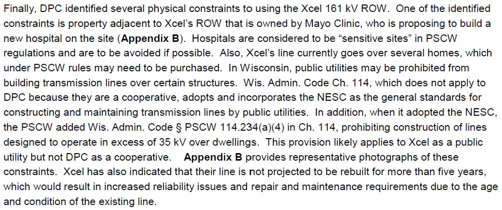
What’s to comment on? I see two issues that should be sufficient to stop this project in its tracks — the debt load of Dairyland Power Cooperative and the physical setting of the project which too near and right over people’s homes.
Debt load — Dairyland Power Cooperative’s debt is excessive and should prohibit taking on more debt:
Dairyland Power Cooperative’s Annual Meeting was last week. One purpose of an organization’s Annual Meeting is to discuss its financial status and approve plans going forward.
Dairyland depends on federal USDA/RUS loans to pay for its transmission expansion, such as the Q-1 transmission upgrades, including Marshland-Briggs Road and now the stretch from Briggs Road to North La Crosse south of I-90. Another USDA/RUS loan paid for Dairyland’s share of the CapX La Crosse line now blighting the bluffs. Dairyland will also be part owner of the MISO Hickory Creek to Cardinal line from Iowa to Madison. That’s a lot of transmission and loans.
Dairyland recognized this financial risk and lopsided debt/equity position, and in 2012 sought help from FERC_(DPC_Request4DeclaratoryOrder), requesting a hypothetical capital structure of 35 percent equity and 65 percent debt when its actual capital structure was 16.5 percent equity and 83.5 percent debt, and FERC did grant this relief in an Order for DPC for CapX 2020 (see FERC Docket, go HERE and plug in docket EL13-19-000). That Order, and the 83.5/16.5% debt/equity ratio was prior to the present Q-1 D South project and the MISO MVP Hickory Creek to Cardinal transmission line. Dairyland requested a “hypothetical” (bogus) debt/equity ratio to preserve its credit rating and enable low cost loans. The true debt level makes DPC a higher risk.
Are Dairyland members aware of the 83.5%/16.5 % debt/equity ratio and reliance on loans for major transmission projects? What’s the debt level where new projects are included? This new transmission enables increased power marketing and sales, a private purpose. Is this highly leveraged position for new transmission in the best interests of Cooperative members?
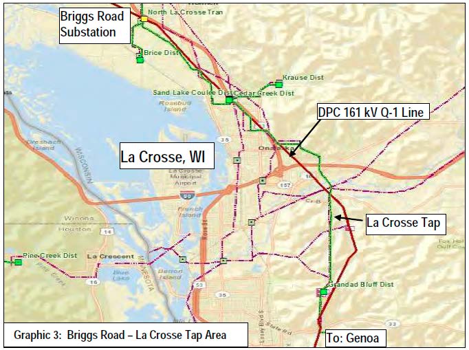
Physical setting of the project — it’s just too close!
The map way above is what the transmission system in the area looks like theoretically, according to the Wisconsin Public Service Commission, but here’s what Dairyland’s Q-1 South line looks like on the ground:
![Ulman_St[1]](https://legalectric.org/f/2016/06/Ulman_St1.jpg)
Really… Here’s what it looks like from a satellite with the lines drawn in, on the far south:
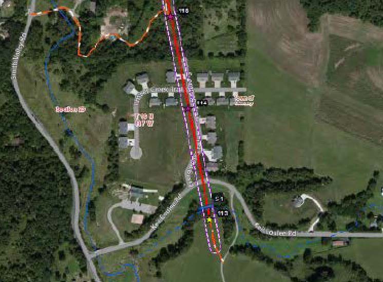
Here’s what it looks like further north — look at all those homes:

And here’s what the Wisconsin PSC Code says about clearances in PSCW 114.234:
(2) Transmission lines over dwelling units. [Follows NESC 234C1b, p. 119] (Addition) Add the following paragraph c:c. Transmission lines over dwelling units.No utility may construct conductors of supply lines designed to operate at voltages in excess of 35 kV over any portion of a dwelling unit. This provision also applies to line conductors in their wind-displaced position as defined in Rule 234A2.Note: It is the intent under s. SPS 316.225(6) that the public not construct any portion of a dwelling unit under such lines.Note: The term “dwelling unit” has the meaning given in ch. SPS 316, which adopts by reference the definitions in NEC-2008.Note: See s. SPS 316.225(6) Clearance Over Buildings and Other Structures, which refers to ch. PSC 114 regarding clearance of conductors over 600 volts and the prohibition of dwellings under or near overhead lines.
USDA’s Dennis Rankin: dennis.rankin@wdc.usda.gov
(I’d also cc DPC’s Chuck Thompson: cat@dairynet.com)
By U.S. Mail:
Dennis Rankin
Environmental Protection Specialist
USDA Rural Utilities Service
1400 Independence Avenue S.W.
Mailstop 1571, Room 2242
Washington, DC 20250-1571
Stephanie Henriksen’s Memorial Service tomorrow
January 18th, 2016
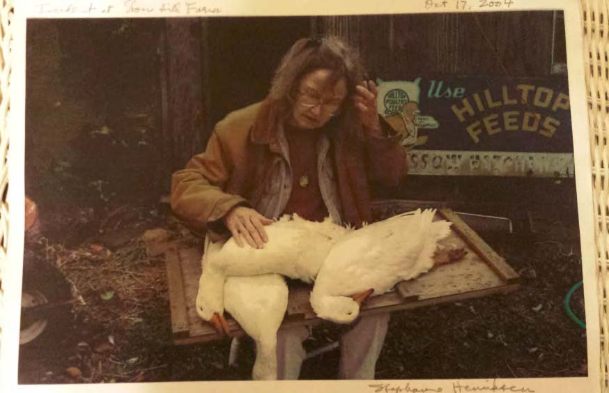 Photo by David Kamis, taken after Stephanie’s ducks were assassinated
Tomorrow is the Memorial Service for Stephanie Henricksen. It’s at the UCC in Northfield, gathering at 10 a.m. and service is at 11 a.m. with lunch following.
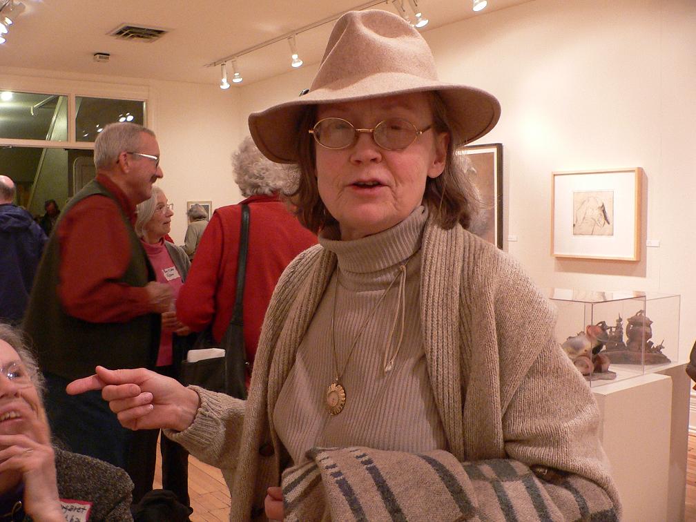 Photo by Kathleen Doran-Norton, of Stephanie, and there’s Dave & Flo Minar in the background
Comparing Bundys v. #blacklivesmatter… are you serious?
January 3rd, 2016
Since the #YallQaeda takeover of the Malheur Wildlife Refuge Headquarters, I’ve been waiting for the comparisons of these guys to #blacklivesmatter. Here we go, from the bubbleheads:
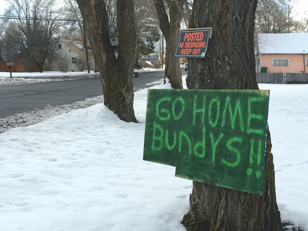
Let’s see, looking at Bundys v. #blacklivesmatter here in Minneapolis: taking over a federal building v. tenting on the grounds; armed v. unarmed; repudiating governmental authority v. working for systemic change; unfocused blather v. concrete demands and issues; unwanted outsiders v. community members; bringing in snipers v. bringing in tents and food; favored and coddled treatment in the press v. scathing condemnation in the press. DOH! And white male leadership v. black female leadership. And these “111” guys, the Bundy folks have it on their T-Shirts, pick up truck rear windows, and the ones who came in and SHOT #blacklivesmatter protesters were part of the group branding themselves with the “111” label.

The Hammonds of Burns, Oregon, the other BLM and Ammon Bundy
January 2nd, 2016
Remember Clive Bundy and his Nevada stand-off when the feds decided to evict him, and his cows, from BLM land they had leased but stopped paying the lease and owes over $1 million?
Now his son Ammon Bundy, from Phoenix, has organized his militia and gone up to Burns, Oregon (temp around 9 today!) for another stand-up/stand-off/stand-down over Dwight and Steven Hammond. another federal land lease issue, where they were convicted of arson, burning the BLM land, and then a federal judge determined that their sentence was not sufficient, and ordered them to report back to prison this coming Monday. Ammon Bundy has issued a “call to arms” which sounds a lot like inciting violence to me. From what I’ve been reading, people are ignoring that this was LEASED land, they did not own it, it was not there, it is OURS, as in “we the people” ours!
Eastern Oregon Ranchers Convicted of Arson Resentenced …

When you check out the videos and photos, note the “111%” on T-shirts and signs.
Militia takes over Malheur National Wildlife Refuge headquarters
Thing is, Dwight and Steven Hammond want nothing to do with Bundy and his militia, the Community doesn’t want them around… they “stand with the Hammonds” but Hammonds not so much…
Who Wants A Burns, Oregon Standoff? Not The Sheriff, The Ranchers, Or Even Cliven Bundy
Oregon ranching case spurs anti-government sentiment
The Hammonds have not welcomed the Bundys’ help.
“Neither Ammon Bundy nor anyone within his group/organization speak for the Hammond Family,” the Hammonds’ lawyer W. Alan Schroeder wrote to Sheriff David Ward. But Hammonds don’t have clean hands, going beyond the federal crimes for which they’ve been convicted and are now serving time:
Showdown in the Malheur marshes: the origins of rancher terrorism in Burns, Oregon
A local resident organized a meeting to address the militia, learn about their plans:
Burns residents confront militia over fears of violence
… This was no government-led meeting. Brandy Mosher, a local resident worried about her community, arranged the meeting, promoting it on social media. On a frigid holiday evening, about 60 people showed up. She just wanted people to talk to each other instead of resorting to rumors.
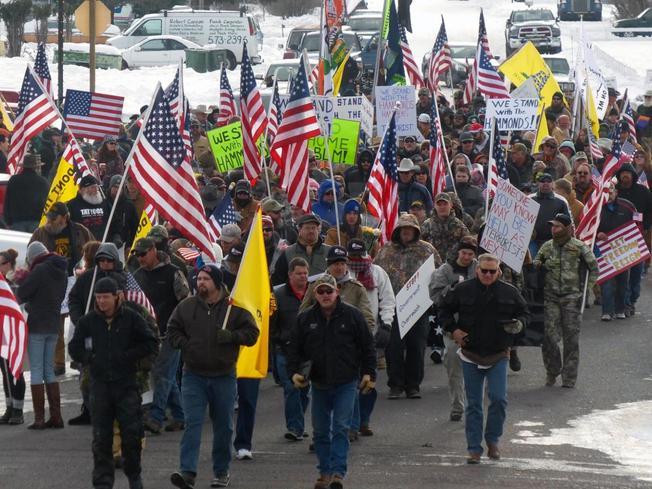
There was a protest this afternoon in Burns, Oregon:
Militia holds march, rally in Burns

After the protest, Bundy brothers and other supporters took over the National Forest Reserve office, and they want to give it back to loggers, miners and the ranchers:
Armed militia, incl Bundy bros, occupy forest reserve HQ in Oregon, call ‘US patriots’ to arms
Convoy takes off from Bend to protest ranchers’ convictions