Comments on EQB Standards & Criteria
October 4th, 2013
On September 18th, the EQB sent staff back to the drawing board to rewrite model Standards and Criteria for silica sand mining… so NOW is the time to be filing comments on your ideas for EQB Standards and Criteria. New EQB Executive Director Will Seuffert has said that at the next meeting he will trot out a schedule for these festivities:
Here’s an example — the Comment drafted on behalf of Winona Co. CASM:
So, what to do? How do write your own comments? Here’s a format and form that may prove useful, see below for suggestions:
Send comments ASAP (the sooner the better) to:
Will.Seuffert@state.mn.us
jeff.smyser@state.mn.us
bob.patton@state.mn.us
kate.frantz@state.mn.us
The legislation passed last year, Minn. Session Laws Ch. 114, sets out categories for these Standards and Criteria (remember, this is NOT rulemaking, not any specific procedure for doing this). They’re needing your thoughts on Standards and Criteria, and there are so many categories that you’re bound to have some thoughts on this.
Many people have said this is just too complicated, and what I suggest is to take it in small pieces. For example, if you care about protecting the bluffs, just select that one row:

One way to do this is to work it backwards, do your research and work from right to left:
1) “Support for language” column, where you’d list the studies that support protection of the bluffs, i.e., “DNR Eco-Regions Subsections map” (with a copy to attach to your comment);
2) “Proposed Language” using that info as basis for language, from a map, studies, state statutes, local ordinances, figure out how bluffs could be protected, such as a prohibition of mining in bluffland areas as depicted by the dark green/grey of this map:
Your comment would look like this:

Or if you’re concerned about water, again, working backwards:
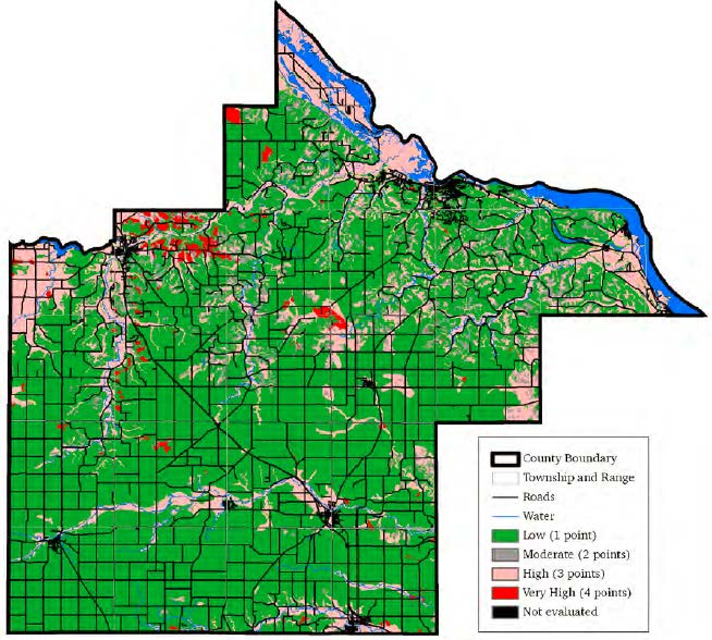
1) “Support for Language” column: Goodhue County map showing Sensitivity to Pollution of the Uppermost Bedrock Aquifers (with copy of map attached to Comment):
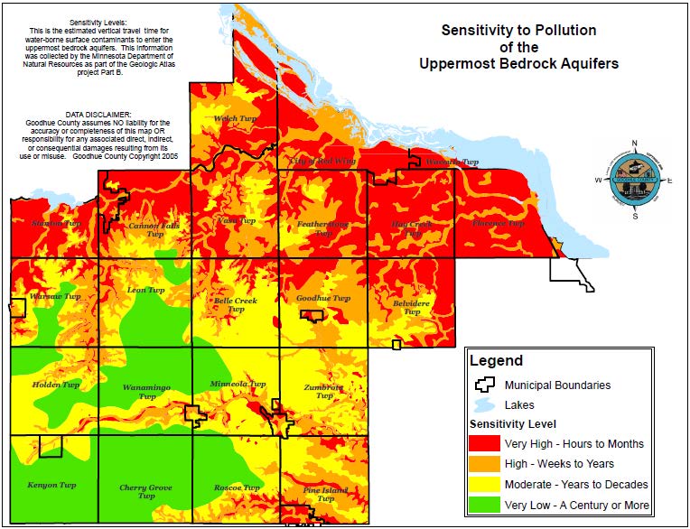
2) “Proposed Language” column: Prohibition of mining in areas with Very High or High sensitivity to pollution of the uppermost bedrock aquifer.
Your comment would look like this:

And another example:

The catch in all of this is that your comments have to specifically relate to the legislatively mandated development of Standards and Criteria — it’s not enough to give vague generalities and rah-rah no frac sand mining here statements. And working backwards seems to be the best way to develop this, to do some basic googling and find studies. Check the Save the Bluffs reference page for some ideas:
Again, here’s a format and form that may prove useful, see below for suggestions:
Send comments ASAP (the sooner the better) to:
Will.Seuffert@state.mn.us
jeff.smyser@state.mn.us
bob.patton@state.mn.us
kate.frantz@state.mn.us
| Standards & Criteria (from statute) | Proposed language | Support for language |
| (1) Setbacks or buffers | ||
| (iv) Bluffs |
Maps at Goodhue Co. Mining Committee
October 1st, 2013
Very interesting…
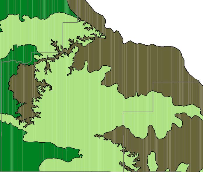
Here is a copy of the map at issue at the Goodhue County Mining Study Committee (see below too):
Ecological Subsections Map
(a similar federal one can be found at http://upload.wikimedia.org/wikipedia/commons/8/8b/Minn_ecoregionsmap.pdf, for origin, see http://en.wikipedia.org/wiki/List_of_ecoregions_in_Minnesota)
This map was presented to the County Mining Study Committee at its last meeting. At issue is how this would be used — the DNR’s boundary is clear, and more specific on other maps somewhere, and a more detailed map with additional layers is likely within the county resources already. Is it a matter of:
- a prohibition of all mining in the grey/green; or
- prohibiting silica sand mining in the grey/green; or
- more intense regulatory scrutiny of proposals in the grey/green; or
- some other option?
I’d vote for the first, with the second as a fall-back.
Use of this map as guidance is a big step forward because it isn’t an arbitrary boundary (a distance is arbitrary), instead it’s one delineated by the DNR (and a good reference for the EQB Standards and Criteria), not just an arbitrary distance. The County is sensitive to the need for this support because of the issues over the wind 10 RD setbacks and loss at the PUC and Appellate Court. They need to be able to refer to something and say, “This is why!” These maps do just that. It’s based on science, it’s based on research of the state agency with the expertise, it’s easy to establish whether something is or is not in the zone, and it’s supportable and defendable in court.
So what it looks like for Goodhue County, without any other layers, is this:
In addition, there’s this “Sensitivity to Pollution of the Uppermost Bedrock Aquifers” map which I’ve not seen before. It’s on the County site, and look at the red “Sensitivity level – very high, hours to months” which should be referenced (it’s similar to, but more dramatic, than the MN Dept. of Health map about nitrate contamination):
Kristen Eide-Tollefson has told me that there’s a Water Sustainability Framework Report, and with directions, lo and behold, I found it (still downloading, must be very large with the maps, won’t download as pdf, grrrrrrrrrrr, firefox has locked up twice):
When you look at big picture, which our aquifer is, there’s nearly universal support for protecting the aquifer, and it’s pretty hard to credibly argue against protecting it. There’s a lot of good information, various maps and studies, to support protections, and that’s important because if the county’s ordinance is challenged, as it has been before, it has to be defendable. Protection of the aquifer is the protection of our natural resource that does something for the entire county.
The Mining Study Committee seems to be on a good track here, looking at bigger picture and stronger regulation moving toward prohibitions.
These maps are also oh-so-relevant information that should be considered by the EQB for the Standards and Criteria that they’re reworking.
Comment on PUC Rulemaking
September 30th, 2013
Yeah, I’m a little slow on the uptake here, but the minutes from the last Public Utilities Commission Rulemaking Committee and the latest rule draft update came out what, a month ago??? Naaaah, more like three weeks, but still… And the next Committee meeting is Wednesday.
Who cares about the rules? Who cares about Minn. R. Ch. 7849? Well, we all should because it’s the way the Commission determines, in this case, whether a particular proposed power plant or transmission line is “needed” or not. It lays out what the applicant must put into an application, it sets the parameters of initial notice for the project generally and the different types of notice as the project moves through the morass that is regulation.
Certificate of Need is the “IF” stage, IF a project will go forward, and not “WHERE” which comes after it’s determined that it’s needed (rightly or wrongly). If a project gets a Certificate of Need, then the next question is WHERE. These rules address forecasts and what types are necessary and how current, if an applicant should be exempted from any of the rules based on the type of project or situation, the (nominal) environmental review in an “Environmental Report,” what avenues are open for public participation such as meetings and public hearings, whether you can question witnesses at the hearings, blah blah… it’s arcane, it might be boring, but it’s what we’ve got to deal with. You can find really painful examples of how the rules do and don’t work here and at www.nocapx2020.info. Please weigh in!
Join us:
Rulemaking Advisory Committee
9-11 a.m. — Wednesday, October 2, 2013
PUC Building Basement (follow signs)
121 East 7th Place
St. Paul, Minnesota 55101
This is about Minn. R. Ch. 7849, the rules covering Certificate of Need.
From the PUC:
We’re getting pretty far along, so this would be a good time to get comments in on the September 10 Draft — QUICK before they issue a formal draft and it’s set in stone.
Aquifer Recharge & Silica Sand Mining
September 29th, 2013
So I’m looking into aquifer recharge in relation to silica sand mining, as protection of the aquifers is a primary necessity. Try googling, and try finding maps that show these areas. Try finding a recharge map! Is it that in Minnesota it’s presumed that we’ll always have water?
The short version is that the last map on this post does indeed have a lot to say about permeability and logically sets out areas of concern that should be protected. This map has been around for a long while, it’s the same map I used to find likely spots for nuclear waste when NSP wanted to put nuclear waste in Goodhue County, and by eliminating the karst areas, and co-locating with rail and the other criteria, voila, Florence Township was the target. This map, and versions of it, go way back. The Goodhue County Mining Study Committee has it, it’s posted online, so why is this taking so long? Why is it so difficult to characterize the areas that should be protected from pollution from frac sand mining? Protection of water is primary on almost everyone’s agenda. Without a safe and clean water supply, where are we? It’s our drinking water, and we’re an agricultural county. Geology is complicated, hydrogeology is even more complicated, but it is not rocket science.
I started looking around… What I learned first is that here in Red Wing, we’re part of the Rush-Vermillion watershed. I had no clue! Here’s the map:

Looking at this map, and how it extends southwest of Lakeville, along the Minnesota River and presumably into Scott County, this demonstrates the importance of protections along the Minnesota River, given all the silica sand mining activity there. And look how far it extends north… does it reach the silica sand mines in the Chippewa River Valley?
Here is USGS information on ground water levels by county.
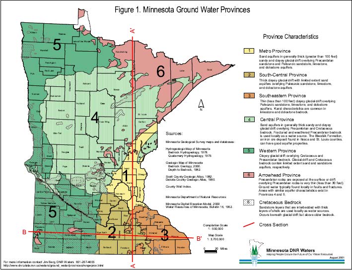
Now, for the Minnesota Groundwater Provinces (click for larger version):
Now for something completely different, Minnesota’s Watershed Districts, designated under Minn. Stat. Ch. 103D. There aren’t that many, only 46, and much of the state is not covered:
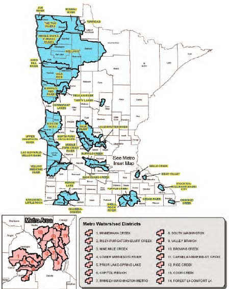 But look where they are! Look at the locations, smack dab in the crucial areas of SE MN, i.e., Belle Creek, Bear Valley, Stockton-Rollingstone-Minnesota City, Crooked Creek, and the contiguous Shell Rock River/Turtle Creek/Cedar River watersheds. These designated Watershed Districts could provide some regulatory protection, maybe a lot, for these areas.
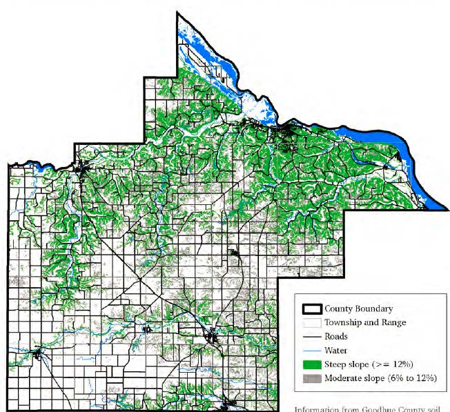
How to protect with an overlay district the area without a lot of geological overlay, the areas between the river and up on top of the edge of the paleolithic plateau, and I presume a bit into the plateau as a setback? Here’s a 2011 Slope Map from a Nitrate-Nitrogen Probability study by the MN Dept of Health:
And a map of hydrogeologic sensitivity of the water table aquifer from the same study, although the study does note that it only addresses vertical migration and not horizontal migration, which is an issue with frac sand mining contaminants as well as the nitrates in the study:
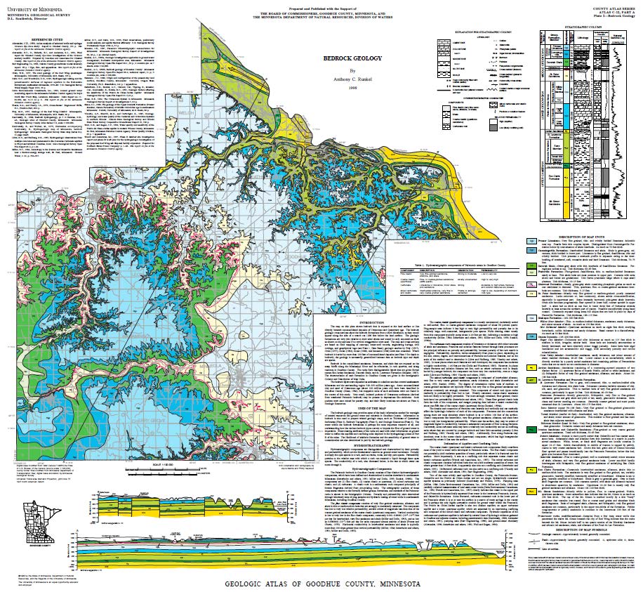
 And of course the U of M Minnesota Geological Survey map, which the county has, which is in the Mining Committee info, they’ve had it forever — can’t they use this? Click on map for larger version:
I’m reading… this is complicated stuff:
Next stop — quest for maps and info directly from the Land Use horse!
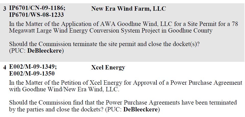
PUC meeting to end Goodhue Wind!
September 27th, 2013

Join us at the Minnesota Public Utilities Commission!
9:30 a.m. on October 10, 2013
PUC Agenda Meeting
121 – 7th Place East, 3rd Floor Mtg Rm
St. Paul, MN 55101
The end of the Goodhue Wind Project… notice just came out for the PUC’s Agenda Meeting on October 10, 2013:
And here’s the good news: