EQB Standards & Criteria in Mankato
October 25th, 2013
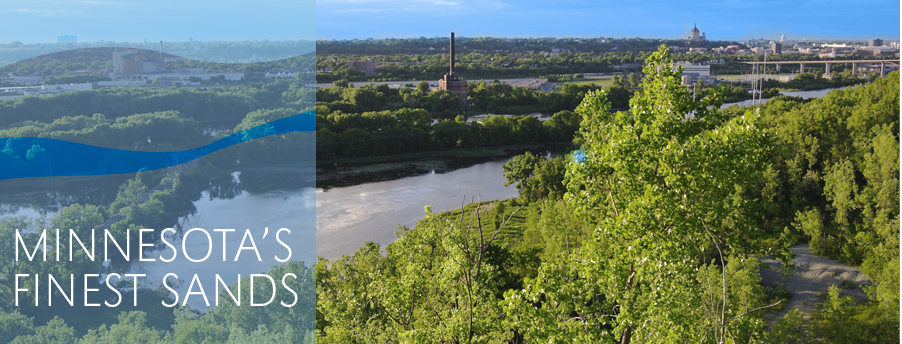
“Minnesota’s Finest Sands.” So says Jordan Sands, the big silica sand mining operation in the Mankato area. And in Mankato we were today, for the EQB meeting about Standards and Criteria:

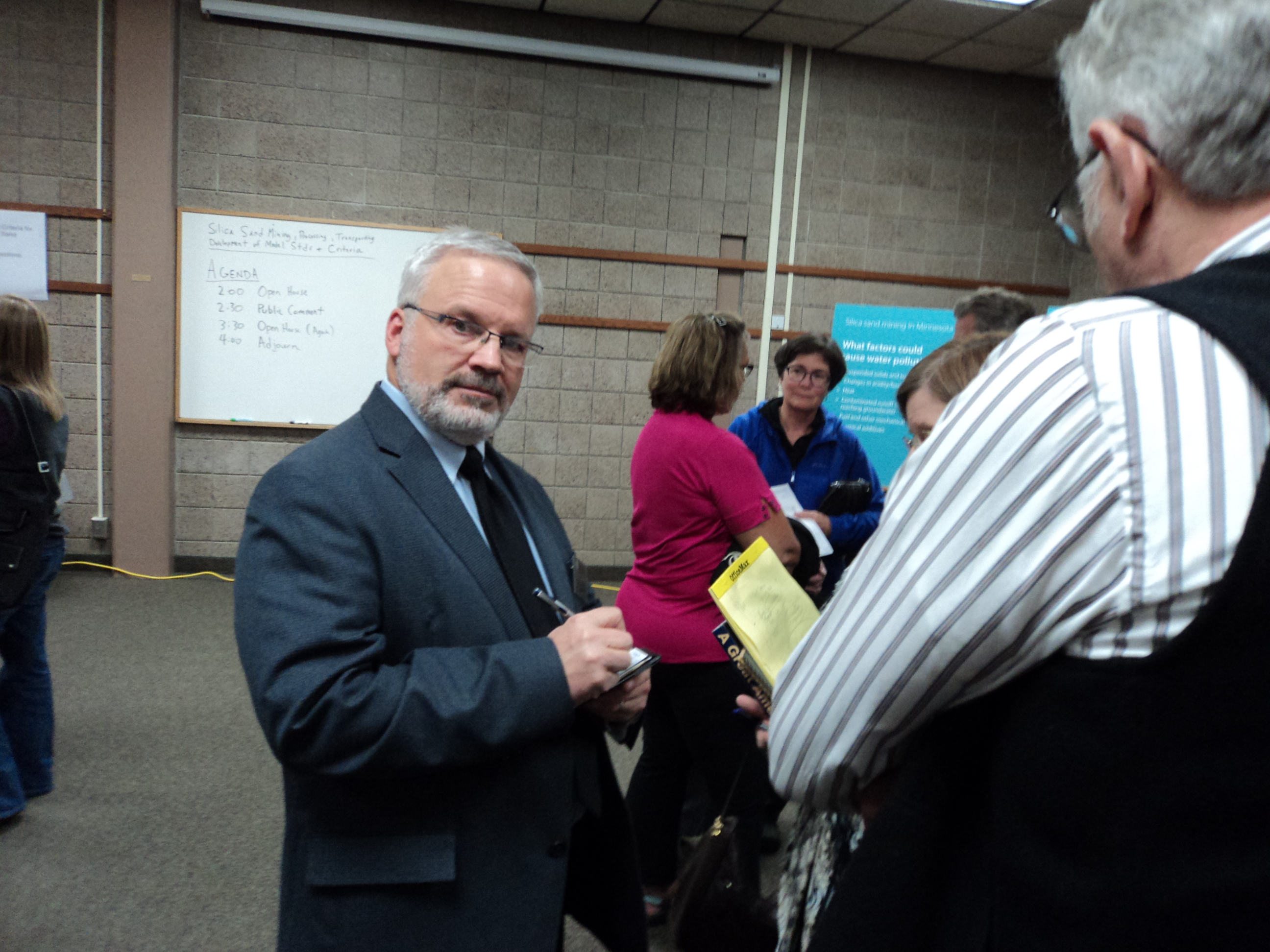
And Jordan Sands, Unimin, etc., were putting out a lot of dough and a lot of time in their multiple representatives at the EQB meeting in Mankato at the Blue Earth County Library. Coming it, it looked well attended. But after a look around, it was apparent that at least half were industry toadies, like my buddy Dennis Egan:
 On the other hand, several direct neighbors of the recently permitted Jordan Sands project, and a township official were there and spoke eloquently of their concerns. Scott County’s environmental crew (3) was there and told of their silica sand mine permitting experience.
I was handing out flyers to help people put in Comments on point about the statutory Standards and Criteria, specific ones that might be meaningful and might be taken into account — it’s hard to get people focused. But my ink jet ran out so I only had a handful. Here it is:
Ag Commissioner Fredrickson and MPCA Commissioner Stine were on hand, as well as DNR Commissioner Landwehr, and others too:

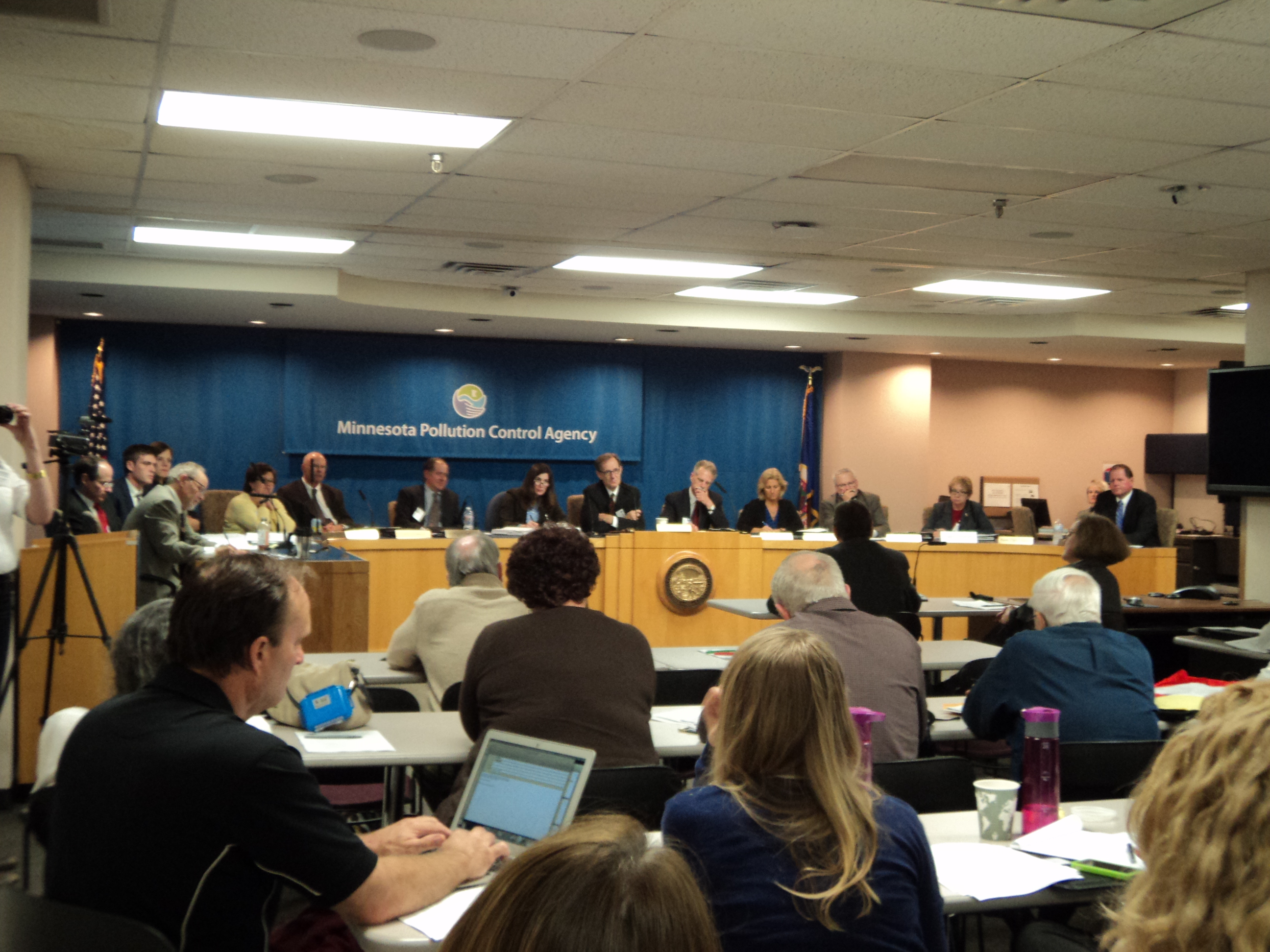
It was a public meeting, in an open house and also presentation/Q&A format where the EQB was soliciting input for the silica sands Standards and Criteria, as directed by last session’s 116C.99:
The standards and criteria must include:
(1) recommendations for setbacks or buffers for mining operation and processing, including:
(i) any residence or residential zoning district boundary;
(ii) any property line or right-of-way line of any existing or proposed street or highway;
(iii) ordinary high water levels of public waters;
(iv) bluffs;
(v) designated trout streams, Class 2A water as designated in the rules of the Pollution Control Agency, or any perennially flowing tributary of a designated trout stream or Class 2A water;
(vi) calcareous fens;
(vii) wellhead protection areas as defined in section 103I.005;
(viii) critical natural habitat acquired by the commissioner of natural resources under section 84.944; and
(ix) a natural resource easement paid wholly or in part by public funds;(2) standards for hours of operation;
(3) groundwater and surface water quality and quantity monitoring and mitigation plan requirements, including:
(i) applicable groundwater and surface water appropriation permit requirements;
(ii) well sealing requirements;
(iii) annual submission of monitoring well data; and
(iv) storm water runoff rate limits not to exceed two-, ten-, and 100-year storm events;(4) air monitoring and data submission requirements;
(5) dust control requirements;
(6) noise testing and mitigation plan requirements;
(7) blast monitoring plan requirements;
(8) lighting requirements;
(9) inspection requirements;
(10) containment requirements for silica sand in temporary storage to protect air and water quality;
(11) containment requirements for chemicals used in processing;
(12) financial assurance requirements;
(13) road and bridge impacts and requirements; and
(14) reclamation plan requirements as required under the rules adopted by the commissioner of natural resources.
Here’s a chart to give people a format and idea how to submit comments — for this exercise, we need to file specific ideas for particular standard/criteria (in the middle column), and it’s very helpful to list whatever supporting documentation or authority you have for this criteria (right hand column), such as a local ordinance, or health studies:
Below is a prior comment I’d sent in for Winona County CASM with some thoughts tossed together — well, at least the EQB used the format I proposed!
Now, back to process — here’s the schedule established at the most recent EQB meeting (last week), Will Seuffert said he was working on that earlier this month…

(ja, the light in there was awful) …and voila, the schedule, here it is:

EQB’s sand site: http://silicasand.mn.gov/
I’m concerned about the focus on SE Minnesota, evidenced by the statutory language, and listening to the words used by the toady from Unimin, that “SE IS UNIQUE” and so it is special, and implying that an open door along the Minnesota River is just fine… NOT! Earth to Mars, frac sand mining is NOT unique to SE Minnesota. Here’s the map:
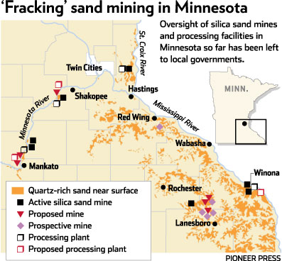
and from the DNR:

Think about where the major spill has been — INTO THE FEDERALLY PROTECTED WILD & SCENIC ST. CROIX RIVER!! Not even close to SE Minnesota. Where did they start up a processing/transport facility with no permits? Harris, MN (is Loren Jennings involved in this???).
And that much is clear from the many who did show up on a Friday afternoon in Mankato, by the permits issued already, Jordan Sands in Mankato, and as addressed by the Scott County environmental guy and other staff people who had just completed an intense permitting process there. Scott (Frenchette?), Scott County, raised a few state statutes, such as Minn. Stat. 103H.01 focused on ground water degradation, 116D.04, Subd. 6 (you all recognize MEPA by now, EH?), 103I and Minn. R. 7060 regarding protection of ground water. He asked about these statutes, all related to state permits, and rhetorically wondered what a local government is to do, is there protection offered in these statutes?
Time to get to work!
Send comments on Standards and Criteria to:
silicasand.eqb@state.mn.us, and copy:
Will.Seuffert@state.mn.us
jeff.smyser@state.mn.us
bob.patton@state.mn.us
kate.frantz@state.mn.us
Deadline is November 12, but the sooner the better, give them some time to incorporate in your thoughts!
Comments on EQB Standards & Criteria
October 4th, 2013
On September 18th, the EQB sent staff back to the drawing board to rewrite model Standards and Criteria for silica sand mining… so NOW is the time to be filing comments on your ideas for EQB Standards and Criteria. New EQB Executive Director Will Seuffert has said that at the next meeting he will trot out a schedule for these festivities:
Here’s an example — the Comment drafted on behalf of Winona Co. CASM:
So, what to do? How do write your own comments? Here’s a format and form that may prove useful, see below for suggestions:
Send comments ASAP (the sooner the better) to:
Will.Seuffert@state.mn.us
jeff.smyser@state.mn.us
bob.patton@state.mn.us
kate.frantz@state.mn.us
The legislation passed last year, Minn. Session Laws Ch. 114, sets out categories for these Standards and Criteria (remember, this is NOT rulemaking, not any specific procedure for doing this). They’re needing your thoughts on Standards and Criteria, and there are so many categories that you’re bound to have some thoughts on this.
Many people have said this is just too complicated, and what I suggest is to take it in small pieces. For example, if you care about protecting the bluffs, just select that one row:

One way to do this is to work it backwards, do your research and work from right to left:
1) “Support for language” column, where you’d list the studies that support protection of the bluffs, i.e., “DNR Eco-Regions Subsections map” (with a copy to attach to your comment);
2) “Proposed Language” using that info as basis for language, from a map, studies, state statutes, local ordinances, figure out how bluffs could be protected, such as a prohibition of mining in bluffland areas as depicted by the dark green/grey of this map:
Your comment would look like this:

Or if you’re concerned about water, again, working backwards:
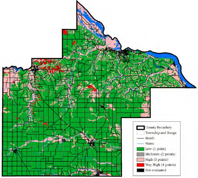
1) “Support for Language” column: Goodhue County map showing Sensitivity to Pollution of the Uppermost Bedrock Aquifers (with copy of map attached to Comment):
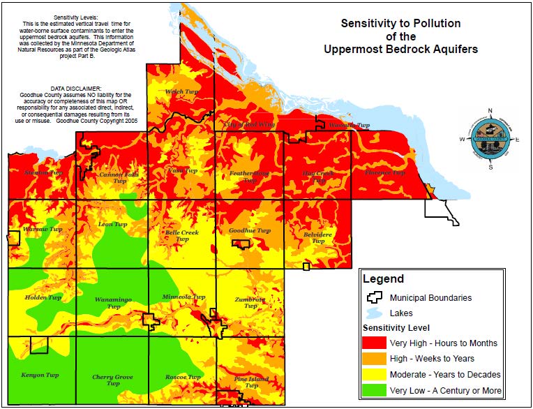
2) “Proposed Language” column: Prohibition of mining in areas with Very High or High sensitivity to pollution of the uppermost bedrock aquifer.
Your comment would look like this:

And another example:

The catch in all of this is that your comments have to specifically relate to the legislatively mandated development of Standards and Criteria — it’s not enough to give vague generalities and rah-rah no frac sand mining here statements. And working backwards seems to be the best way to develop this, to do some basic googling and find studies. Check the Save the Bluffs reference page for some ideas:
Again, here’s a format and form that may prove useful, see below for suggestions:
Send comments ASAP (the sooner the better) to:
Will.Seuffert@state.mn.us
jeff.smyser@state.mn.us
bob.patton@state.mn.us
kate.frantz@state.mn.us
| Standards & Criteria (from statute) | Proposed language | Support for language |
| (1) Setbacks or buffers | ||
| (iv) Bluffs |
Maps at Goodhue Co. Mining Committee
October 1st, 2013
Very interesting…
Here is a copy of the map at issue at the Goodhue County Mining Study Committee (see below too):
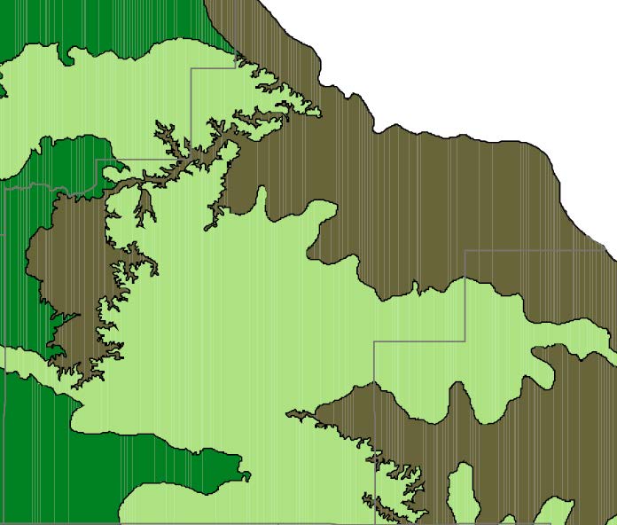
Ecological Subsections Map
(a similar federal one can be found at http://upload.wikimedia.org/wikipedia/commons/8/8b/Minn_ecoregionsmap.pdf, for origin, see http://en.wikipedia.org/wiki/List_of_ecoregions_in_Minnesota)
This map was presented to the County Mining Study Committee at its last meeting. At issue is how this would be used — the DNR’s boundary is clear, and more specific on other maps somewhere, and a more detailed map with additional layers is likely within the county resources already. Is it a matter of:
- a prohibition of all mining in the grey/green; or
- prohibiting silica sand mining in the grey/green; or
- more intense regulatory scrutiny of proposals in the grey/green; or
- some other option?
I’d vote for the first, with the second as a fall-back.
Use of this map as guidance is a big step forward because it isn’t an arbitrary boundary (a distance is arbitrary), instead it’s one delineated by the DNR (and a good reference for the EQB Standards and Criteria), not just an arbitrary distance. The County is sensitive to the need for this support because of the issues over the wind 10 RD setbacks and loss at the PUC and Appellate Court. They need to be able to refer to something and say, “This is why!” These maps do just that. It’s based on science, it’s based on research of the state agency with the expertise, it’s easy to establish whether something is or is not in the zone, and it’s supportable and defendable in court.
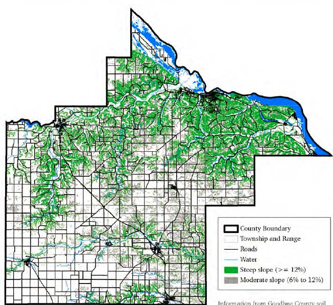
So what it looks like for Goodhue County, without any other layers, is this:
In addition, there’s this “Sensitivity to Pollution of the Uppermost Bedrock Aquifers” map which I’ve not seen before. It’s on the County site, and look at the red “Sensitivity level – very high, hours to months” which should be referenced (it’s similar to, but more dramatic, than the MN Dept. of Health map about nitrate contamination):
Kristen Eide-Tollefson has told me that there’s a Water Sustainability Framework Report, and with directions, lo and behold, I found it (still downloading, must be very large with the maps, won’t download as pdf, grrrrrrrrrrr, firefox has locked up twice):
When you look at big picture, which our aquifer is, there’s nearly universal support for protecting the aquifer, and it’s pretty hard to credibly argue against protecting it. There’s a lot of good information, various maps and studies, to support protections, and that’s important because if the county’s ordinance is challenged, as it has been before, it has to be defendable. Protection of the aquifer is the protection of our natural resource that does something for the entire county.
The Mining Study Committee seems to be on a good track here, looking at bigger picture and stronger regulation moving toward prohibitions.
These maps are also oh-so-relevant information that should be considered by the EQB for the Standards and Criteria that they’re reworking.
Aquifer Recharge & Silica Sand Mining
September 29th, 2013
So I’m looking into aquifer recharge in relation to silica sand mining, as protection of the aquifers is a primary necessity. Try googling, and try finding maps that show these areas. Try finding a recharge map! Is it that in Minnesota it’s presumed that we’ll always have water?
The short version is that the last map on this post does indeed have a lot to say about permeability and logically sets out areas of concern that should be protected. This map has been around for a long while, it’s the same map I used to find likely spots for nuclear waste when NSP wanted to put nuclear waste in Goodhue County, and by eliminating the karst areas, and co-locating with rail and the other criteria, voila, Florence Township was the target. This map, and versions of it, go way back. The Goodhue County Mining Study Committee has it, it’s posted online, so why is this taking so long? Why is it so difficult to characterize the areas that should be protected from pollution from frac sand mining? Protection of water is primary on almost everyone’s agenda. Without a safe and clean water supply, where are we? It’s our drinking water, and we’re an agricultural county. Geology is complicated, hydrogeology is even more complicated, but it is not rocket science.
I started looking around… What I learned first is that here in Red Wing, we’re part of the Rush-Vermillion watershed. I had no clue! Here’s the map:

Looking at this map, and how it extends southwest of Lakeville, along the Minnesota River and presumably into Scott County, this demonstrates the importance of protections along the Minnesota River, given all the silica sand mining activity there. And look how far it extends north… does it reach the silica sand mines in the Chippewa River Valley?
Here is USGS information on ground water levels by county.
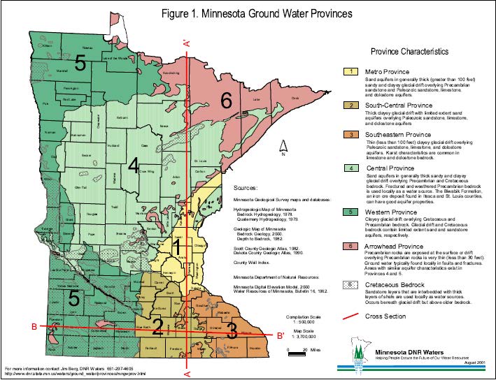
Now, for the Minnesota Groundwater Provinces (click for larger version):
Now for something completely different, Minnesota’s Watershed Districts, designated under Minn. Stat. Ch. 103D. There aren’t that many, only 46, and much of the state is not covered:
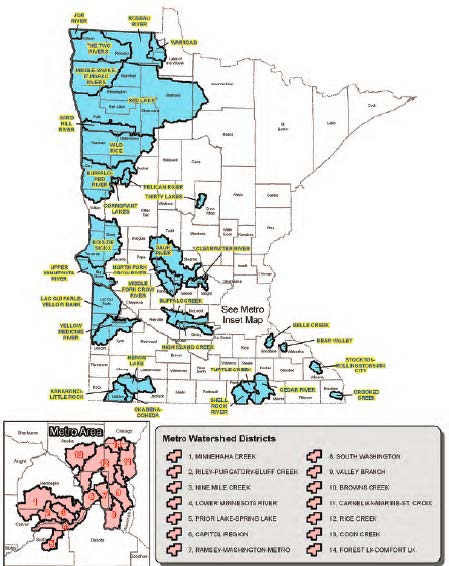 But look where they are! Look at the locations, smack dab in the crucial areas of SE MN, i.e., Belle Creek, Bear Valley, Stockton-Rollingstone-Minnesota City, Crooked Creek, and the contiguous Shell Rock River/Turtle Creek/Cedar River watersheds. These designated Watershed Districts could provide some regulatory protection, maybe a lot, for these areas.
How to protect with an overlay district the area without a lot of geological overlay, the areas between the river and up on top of the edge of the paleolithic plateau, and I presume a bit into the plateau as a setback? Here’s a 2011 Slope Map from a Nitrate-Nitrogen Probability study by the MN Dept of Health:
And a map of hydrogeologic sensitivity of the water table aquifer from the same study, although the study does note that it only addresses vertical migration and not horizontal migration, which is an issue with frac sand mining contaminants as well as the nitrates in the study:
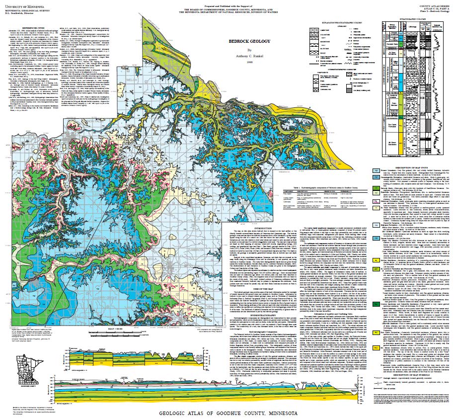
 And of course the U of M Minnesota Geological Survey map, which the county has, which is in the Mining Committee info, they’ve had it forever — can’t they use this? Click on map for larger version:
I’m reading… this is complicated stuff:
Next stop — quest for maps and info directly from the Land Use horse!
The rest of the story… ???
September 27th, 2013
Back to transmission lines and pipelines…
Looking at the footprints, at what’s proposed, it makes sense, meaning that it fits together, the rest of the story. But does it? There’s the Not-So-Great Northern Transmission Line (Minnesota Power’s Great Northern Transmission Line), and there’s the Enbridge Sandpiper pipeline. But is it all connected? Or is there even more in store? How much do these companies want?
The Not-So-Great Northern Transmission Line:
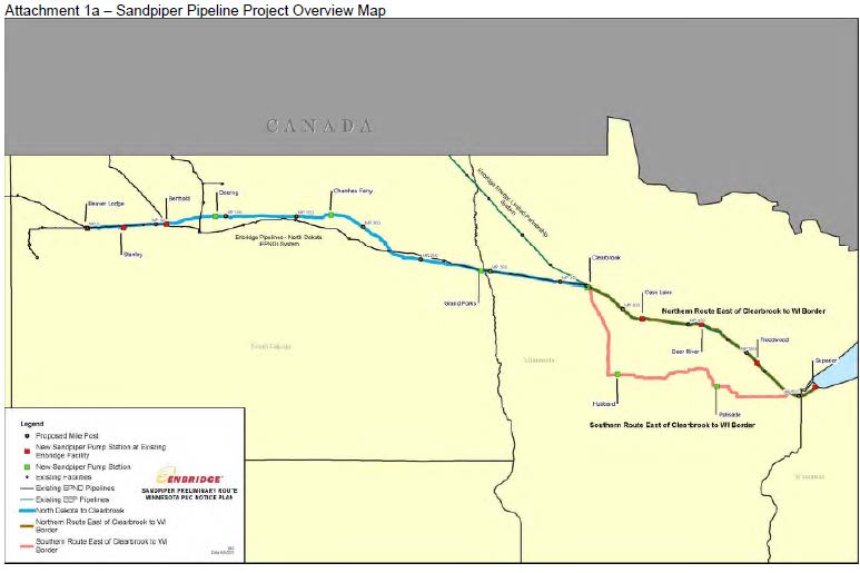
And there’s the Enbridge Sandpiper pipeline:
And then there’s this, the Allete Energy Corridor:
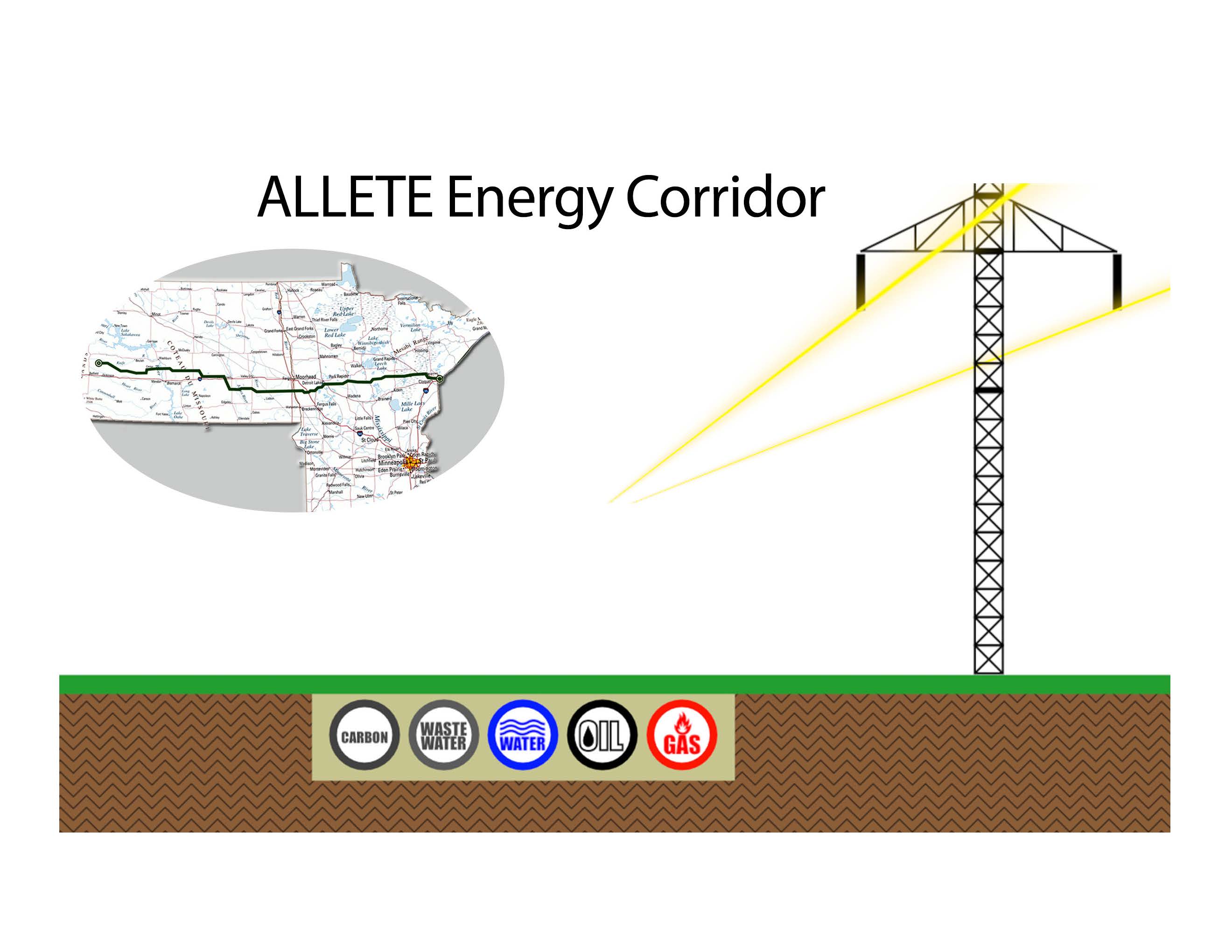 There are differences… the Allete Energy Corridor is further south, headed straight east to Duluth. But look at the map that is in their Notice Plan, the “Preferred Route.” It’s also south:
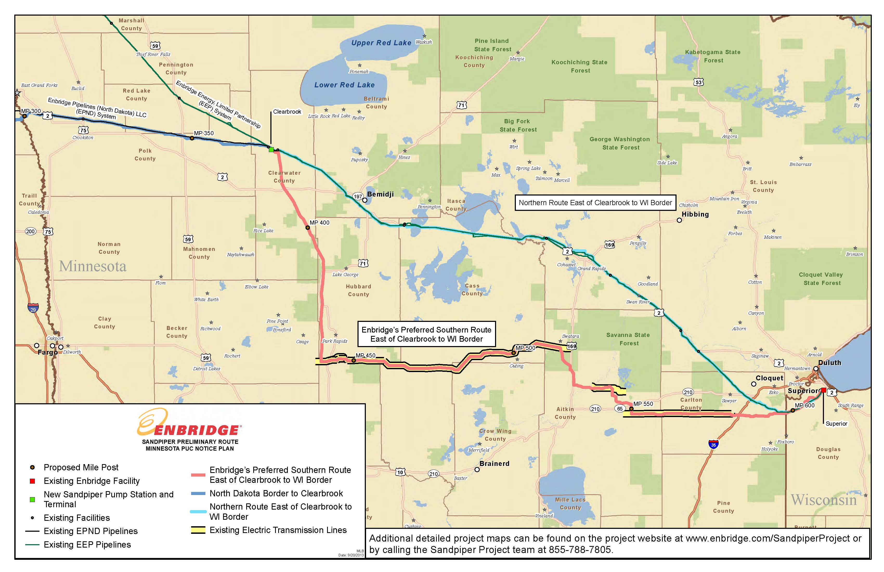
Do they need both? Is this all one and the same project(s)? As we say in transmission, it’s all connected. So do tell, what’s the connection with the two announced projects, one transmission and one pipeline, and this “energy corridor.” Enbridge must submit more detailed maps for the Notice Plan, so we should see soon their “preference.”
Meanwhile, what’s Allete up to? Seems it started over two years ago:
And yesterday:
ALLETE Energy Corridor Would Offer Efficient Movement of Multiple Products, from Flared Gas to Water
by Business Wire via The Motley Fool Sep 25th 2013 12:30PM
Updated Sep 25th 2013 12:32PM
ALLETE Energy Corridor Would Offer Efficient Movement of Multiple Products, from Flared Gas to Water to Carbon
N.D. governor supports comprehensive solution
BISMARCK, N.D.–(BUSINESS WIRE)– ALLETE (NYS: ALE) today laid out its vision for a comprehensive energy transportation corridor that could help provide solutions for the movement of natural gas, petroleum products, water and wastewater, wind energy and future sequestered carbon across a coordinated, shared right-of-way.
The energy corridor’s backbone would follow an existing 465-mile path that contains a direct current transmission line running between Center, N.D. and Duluth, Minn. This 250-kilovolt line, purchased in 2009, is used to transmit electric energy from the lignite-fired Young Generating Station in Center and the nearby Bison Wind Energy Center to Duluth, Minn., home of the nation’s busiest inland seaport. The energy corridor would expand a pathway along strategic portions of the existing right of way to minimize land use and optimize energy delivery infrastructure development within North Dakota.
A top priority of the ALLETE Energy Corridor is to develop an extension of the existing energy delivery path some 60 miles westward to the burgeoning Bakken shale oil fields of west-central North Dakota. ALLETE subsidiary ALLETE Clean Energy has been working diligently with potential partners to study the co-location of facilities and assess the capital needs for the Bakken link. It is envisioned that various lengths of the corridor would be used for different purposes.
“We see the ALLETE Energy Corridor as a comprehensive infrastructure solution in North Dakota that could serve many products and producers across the region,” said ALLETE President, Chairman and CEO Alan R. Hodnik. “We value Gov. Dalrymple’s support of our vision and appreciate him bringing it forward to other members of the state’s energy sector.”
“ALLETE has been invested in North Dakota for decades,” Hodnik added. “We are confident that our rich history of partnering with others can help forge creative solutions to today’s new challenges facing energy markets in the Upper Midwest.”
North Dakota Governor Jack Dalrymple voiced support of the ALLETE Energy Corridor today in remarks to EmPower North Dakota, a commission established to develop a comprehensive energy policy for the state. He said the energy corridor concept is a prime example of the way business can creatively tackle pressing problems like the proliferation of flare gas at oil wells dotting the Bakken field, and the traffic tie-ups caused by too many trucks and trains hauling petroleum products to market.
“The ALLETE Energy Corridor is a breakthrough opportunity to reduce flaring by locating a major natural gas pipeline from the Bakken to eastern markets,” Gov. Jack Dalrymple said. “While the corridor would support the transfer of many energy resources, it could also carry carbon dioxide from coal-fired power plants to western North Dakota for use in advanced oil recovery.”
The ALLETE Energy Corridor could accommodate several pipelines capable of transporting natural gas that would otherwise be flared, as well as wastewater and carbon sequestered from fossil fuel generation. Future wind expansions could also benefit.
“We look forward to working with project developers and government officials to implement this vision,” said Eric Norberg, president of ALLETE Clean Energy. “We have an opportunity to pursue investments that will help solve some current issues and lay the groundwork for more efficient movement of energy products, water and wastewater in the future.”
More information about the ALLETE Energy Corridor can be found www.ALLETECleanEnergy.com.
ALLETE, Inc., an energy company based in Duluth, Minn., has a well-established presence in North Dakota that includes BNI Coal, now undergoing a major expansion to extend coal delivery to its partner Minnkota Power, and the Bison Wind Energy Center, where work on a $350 million fourth phase is scheduled to begin this year. ALLETE’s energy businesses also include Minnesota Power, Superior Water, Light & Power Co. and ALLETE Clean Energy. More information about the company is available at www.allete.com.
The statements contained in this release and statements that ALLETE may make orally in connection with this release that are not historical facts, are forward-looking statements. These forward-looking statements involve risks and uncertainties and investors are directed to the risks discussed in documents filed by ALLETE with the Securities and Exchange Commission.
Photos/Multimedia Gallery Available: http://www.businesswire.com/multimedia/home/20130925005251/en/