Challenge of Xcel’s new Mississippi River crossing
November 15th, 2025
Filed this week in Ramsey County District Court, a Minnesota Environmental Rights Act challenge of Xcel’s “Minnesota Energy Connection” transmission line’s crossing of the Mississippi River, a 3.2 mile segment of its 185 radial transmission line The purpose of this transmission line is to allow Xcel to retain its “valuable transmission interconnection rights,” at an expense to ratepayers of $1.367 BILLION. Yes, that’s BILLION!
Before this transmission project had even been applied for, the Dept. of Natural Resources let Xcel know, in writing, that it did wanted Xcel to utilize existing transmission line crossings of the Mississippi for this project, that it should not use a new crossing. And not just this initial Comment, but followed by others too! Why use an existing crossing, why not use this new crossing that Xcel wanted? Well, there are so many reasons…
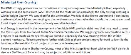
DNR Comments, July 10, 2023, prior to Application, included in Application Appendix E. Remember that first sentence? Here it is again in a later comment:
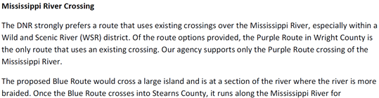
DNR Scoping Comments, February 2, 2024 (attached). And that first sentence? Once more with feeling:
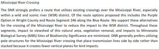
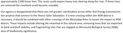
DNR Comments, November 25, 2024.
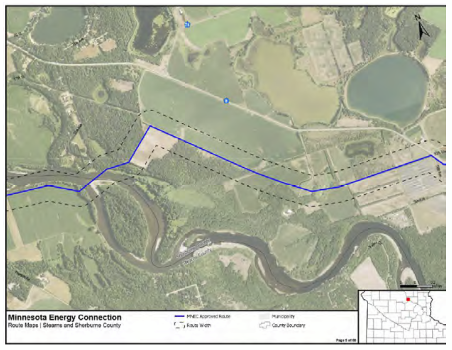
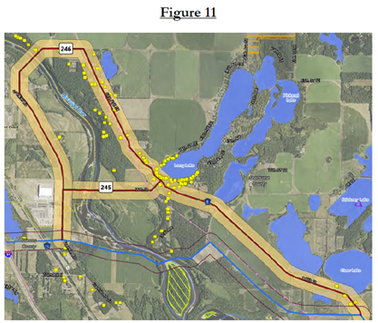
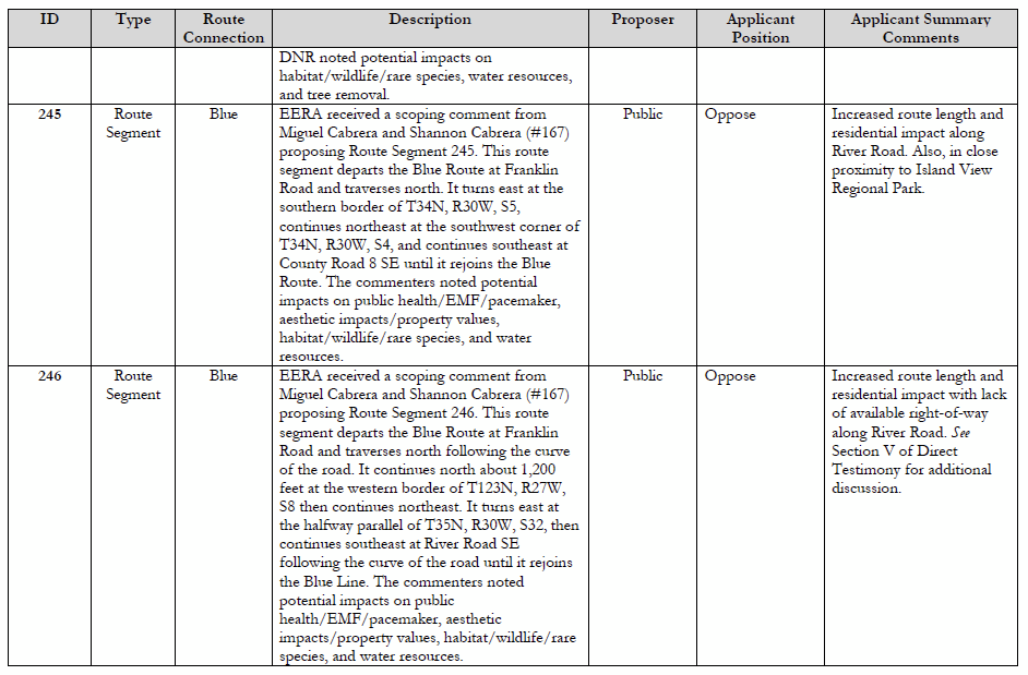
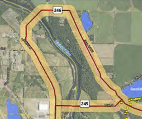
These tan routes in Figure 11 were preferred by the DNR, in addition to the “Purple Route” and expressly NOT the Xcel preferred route, the BLUE LINE route on the map:
Rather than pay attention and site it properly, Xcel hid the DNR’s “STRONG preference” and with more than a little sleight of hand, in its “Response to Agency Comments,” on page 2:
The ALJ omitted it from “DNR Route Preference” citing Xcel, not the DNR (!), and this “MDNR Route Preference” appeared in the Recommendation as if it WERE the DNR’s preference, which it was not, and next it morphed into what was called a “DNR Proxy Route.”
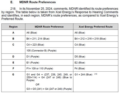
The excuse for this “DNR Proxy Route,” also in the ALJ’s report, the “DNR Proxy Route” that omitted the DNR’s one “strong preference” is convoluted and does not account for the DNR STRONG preference of the Purple Route or Route Segment 246 of the Blue Route:
Citing Xcel and not the DNR. “… to allow for some comparison among MDNR’s route preferences…” Oh, give me a break…
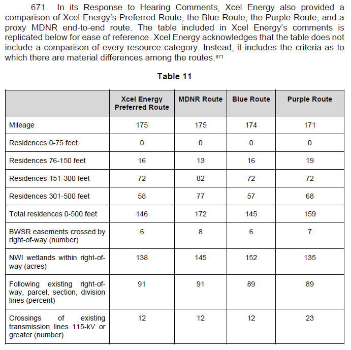
Again, basing this “MDNR Route” on Xcel’s Response to Hearing Comments.
The so-called “Evidentiary Hearing” was a farce, a transcript of 10 pages shows that there was little discussed, and the DNR was not called in to testify!
The “DNR Proxy Route” carried through to Staff Briefing Papers and to the Public Utilities Commission’s ultimate Order. Here’s the story from that Order:
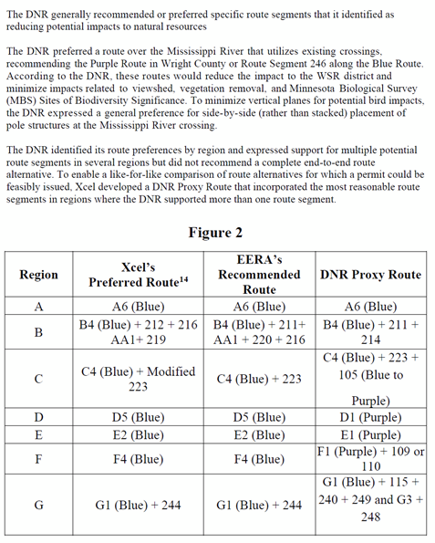
“To enable a like-for-like comparison of route alternatives for which a route could be feasibly issued, Xcel developed a DNR Proxy Route that incorporated the most reasonable route segments in regions where the DNR supported more than one route segment.” Hmmmm, no mention of the DNR’s support of more than one segment crossing the Mississippi — the Purple Route and Route Segment 246 of the Blue Route. How did they get by with this omission?
The last line, “G” of that chart includes the Mississippi River Crossing, and it does NOT include the DNR’s preference of the “Purple Route” or Route Segment 246 of the Blue Route, bot utilizing existing Mississippi River crossings.
Once more with feeling:
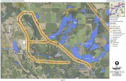
In this map above, note how the Route Segment 246, proposed to utilize existing transmission for the Mississippi River crossing and route, was inexplicably routed not on the existing transmission side of County Road 8, proposed to utilize existing transmission corridor, but on the side of County Road 8 with NO transmission and with a large cluster of lakefront homes!
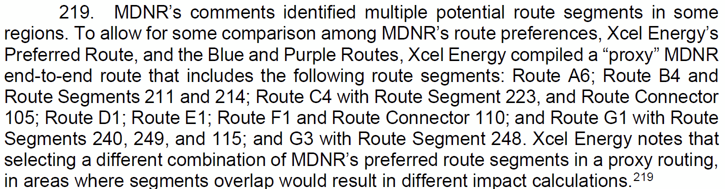
Xcel dismissed these two alternatives in Direct Testimony of Langan and attachments:
And then there’s the matter of burying the DNR Comments. The DNR is the agency charged with protection of our natural resources. Despite this charge, the Comments were hidden in the “Combined Hearing Exhibit” list filed by Xcel, and in the Dept. of Commerce’s long list of exhibits identified only by the eDockets filing number. The DNR Comments were not made an independent part of the record, and agency Comments were not identified in the “Combined Hearing Exhibit List.” Instead, these Comments were entered in a jumble of all the Comments received, with 15 links to batches of “Public Scoping Comments” labeled EERA-4. The DNR’s multiple Comments are buried within eDocket Document ID 20243-204514-03, pages 183-220 of the 227 page “Combined Hearing Exhibit List” filing. Is that nearly impossible to find? You betcha. To find them requires believing, knowing, that they’re there somewhere, opening each link and scrolling through thousands of pages of comments. Another DNR Comment is in the Xcel Application, Appendix E, which also requires knowing it’s there, and though the DNR Comment in Xcel’s Application is cited, once, it does not mention the opening sentence about the Mississippi River crossing stating its strong preference for an existing Mississippi River crossing. That initial sentence was repeated as the initial sentence of each comment regarding the Mississippi River crossing, yet omitted…
Note that when the ALJ in her Recommendation cites the DNR, she’s more often using “Xcel’s Response to Hearing Comments” which incorrectly characterizes, misstates, and omits the DNR’s strong preference of an existing Mississippi River crossing. If the ALJ cites actual DNR Comments, it’s from eDockets, and not a hearing exhibit from the “Combined Hearing Exhibits list, so not referring to a hearing exhibit! Hmmmmmmm…
This river crossing segment is a roughly 3.2 mile section of the 185 mile route, maybe 1.8% of this route? A similar portion of the cost? How hard can it be to route the transmission line with the existing transmission line along County Road 8, avoid all those lakeshore homes they’re so concerned about, and use an existing crossing of the Mississippi River?
We shall see… we’re asking Xcel to stop land acquisition activities on this small section, stop construction prep, stop final engineering, etc., as this winds it way through Ramsey County Court. Yes, we shall see…
p.s. look at this map, look at the pink transmission line alongside of County Road 8. In the Draft and Final EIS, that transmission line disappears as it heads to, or from, the northwest, it disappears to the right of the river crossing. Yes, it disappears! It’s hard to see here — I need to make a HUGE copy of this map!
Leave a Reply