Lava Ridge Wind EIS Comments due March 21
February 1st, 2023
The blue/purple area is the rough footprint of Magic Valley (subsidiary of LS Power) Lava Ridge wind project, by Twin Falls, Idaho. It’s even closer to the Minidoka National Historic Site, the location of a Japenese internment camp during WWII.
Friends of Minidoka have taken an interest and are posting great info on how to write comments, how to participate, because of course participation is where it’s at. Here’s their “Call to Action” page.
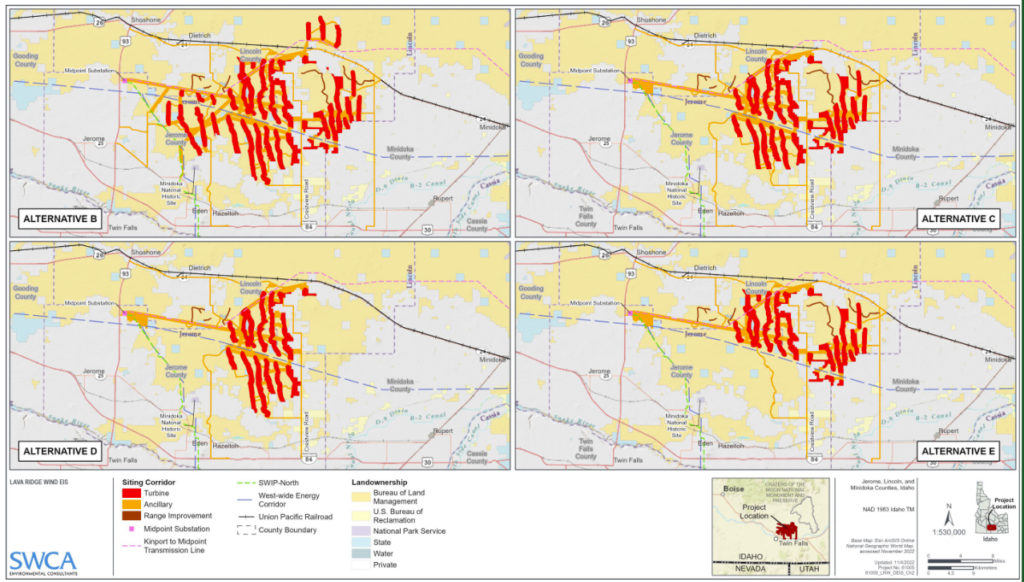
The applicants for Lava Ridge propose several alternate footprints:
Zoom about this on NOW.
The Lava Ridge EIS is out and open for comments, and it’s a LOT to review.
COMMENTS DUE BY MARCH 21, 2023
Here are links, starting with the Executive Summary and in order of appearance (there’s really no easy way to do this, and be prepared, just that first one with the narrative, it’s 578 pages long):
- https://eplanning.blm.gov/public_projects/2013782/200493266/20072054/250078236/Lava_Ridge_DEIS_V1_ExecSum-Chapters.pdf
- https://eplanning.blm.gov/public_projects/2013782/200493266/20072051/250078233/Lava_Ridge_DEIS_V2a_App1_POD_(1%20of%202).pdf
- https://eplanning.blm.gov/public_projects/2013782/200493266/20072053/250078235/Lava_Ridge_DEIS_V2b_App1_POD_(1%20of%202).pdf
- https://eplanning.blm.gov/public_projects/2013782/200493266/20072055/250078237/Lava_Ridge_DEIS_V3_Apps2-4_and_6-11.pdf
- https://eplanning.blm.gov/public_projects/2013782/200493266/20072050/250078232/Lava_Ridge_DEIS_V4a_App5_(1%20of%2013).pdf
- https://eplanning.blm.gov/public_projects/2013782/200493266/20072052/250078234/Lava_Ridge_DEIS_V4b_App5_(2%20of%2013).pdf
- https://eplanning.blm.gov/public_projects/2013782/200493266/20072056/250078238/Lava_Ridge_DEIS_V4c_App5_(3%20of%2013).pdf
- https://eplanning.blm.gov/public_projects/2013782/200493266/20072057/250078239/Lava_Ridge_DEIS_V4d_App5_(4%20of%2013).pdf
- https://eplanning.blm.gov/public_projects/2013782/200493266/20072061/250078243/Lava_Ridge_DEIS_V4e_App5_(5%20of%2013).pdf
- https://eplanning.blm.gov/public_projects/2013782/200493266/20072058/250078240/Lava_Ridge_DEIS_V4f_App5_(6%20of%2013).pdf
- https://eplanning.blm.gov/public_projects/2013782/200493266/20072059/250078241/Lava_Ridge_DEIS_V4g_App5_(7%20of%2013).pdf
- https://eplanning.blm.gov/public_projects/2013782/200493266/20072060/250078242/Lava_Ridge_DEIS_V4h_App5_(8%20of%2013).pdf
- https://eplanning.blm.gov/public_projects/2013782/200493266/20072062/250078244/Lava_Ridge_DEIS_V4i_App5_(9%20of%2013).pdf
- https://eplanning.blm.gov/public_projects/2013782/200493266/20072063/250078245/Lava_Ridge_DEIS_V4j_App5_(10%20of%2013).pdf
- https://eplanning.blm.gov/public_projects/2013782/200493266/20072064/250078246/Lava_Ridge_DEIS_V4k_App5_(11%20of%2013).pdf
- https://eplanning.blm.gov/public_projects/2013782/200493266/20072065/250078247/Lava_Ridge_DEIS_V4l_App5_(12%20of%2013).pdf
- https://eplanning.blm.gov/public_projects/2013782/200493266/20072101/250078283/Lava_Ridge_DEIS_V4m_App5_(13%20of%2013).pdf
Of course, the Applicant’s Noise study/report is of great interest to me:
The good news, the BEST news, is that they did use the correct ground factor, 0.0, for their modeling, but wait, that’s not correct. They used a factor of 1.0 and a factor of 0.6 in places:
That’s a map we need to see!!
It sure looks like some folks are too close, or surrounded:


Leave a Reply