Some Considerations re: Walleye Wind Draft Site Permit
May 15th, 2021

It’s time to comment on the Walleye Wind Draft Site Permit, and the Certificate of Need too.

There are longstanding problems with siting wind projects — the only statutory guidance for wind siting is:
216F.03 SITING OF LWECS.
The legislature declares it to be the policy of the state to site LWECS in an orderly manner compatible with environmental preservation, sustainable development, and the efficient use of resources.
Fat lot of good that does… Rules were mandated, but wind specific siting rules have yet to be promulgated. I’ve been struggling with this for years, 3 rulemaking petitions all denied, lawsuits, even challenging permits at the appellate court… striking out over and over and over and over.
************************
Back to comments. If you’re commenting, be sure to start off labeling the Comment with the docket numbers, PUC Docket IP-7026/WS-20-384 for the Site Permit, and IP-7026/CN-20-269 for the Certificate of Need.
To look up the dockets (one at a time!!), go to “Docket Search” HERE and at “Search” plug in “20” for the year, and either “269” or “384” to get into the docket.

From Docket 20-384, pull up the Draft Site Permit. It’s in the Order, Docket ID 20213-172143-01, dated 3/24/2021. Here it is, separated out from the Order:
Start your comment out by identifying yourself, all contact information, and using the maps below, state your “receptor” number(s) and the turbine numbers that affect you.
Then start wading through the Draft Site Permit.
Page by page, some things that affect people on the ground are, for example, the ability of the developer to change the location of turbines, and just disclose this in the final site plan. See Draft Site Permit Section 3.1, and final site plan Section 10.3. That’s a lot of wiggle room!
Another problematic section, perhaps the most, is Draft Site Permit, Section 4, Setbacks. These should each be addressed separately.
Section 4.1 Wind Access Buffer states”
Wind turbine towers shall not be placed less than five rotor diameters on the prevailing wind directions and three rotor diameters on the non-prevailing wind directions from the perimeter of the property where the Permittee does not hold the wind rights, without the approval of the Commission. This section does not apply to public roads and trails.
Have they complied with this setback? For the 2.32MW turbine, at rotor diameter of 382 feet that means 3x = 1,146 feet and 5x = 1,910. For the 2.82MW turbine with rotor diameter of 417 feet, 3x = 1,251 and 5x = 2,085. That’s the distance required from PROPERTY BOUNDARY of non-participants. Is this happening?
Do ask them to identify where this 3×5 rotor diameter setback comes from! Is it statute? Is it rule? Are they yet again improperly relying on the small wind(under 25MW) Order Establishing General Permit Standards (January 11, 2008)? See Environmental Report, p. 12, 101. This is an application for a LARGE Wind Energy Conversion System, not a small wind project under 25MW.
On to Draft Site Permit, Section 4.2 Residences:
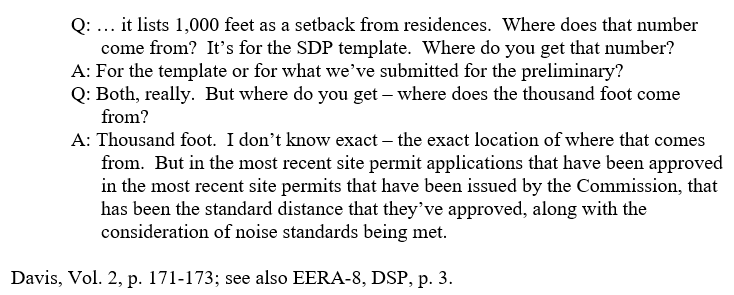
Wind turbine towers shall not be located closer than 1,000 feet from all residences or the distance required to comply with the noise standards pursuant to Minn. R. 7030.0040, established by the Minnesota Pollution Control Agency (MPCA), whichever is greater.
Again, where does this “setback” come from? In the Freeborn Wind docket, when we asked Commerce the source of this Draft Site Permit language for the 1,000 foot setback from residences, EERA’s Rich Davis answered:
Next up in the Draft Site Permit setbacks is Section 4.3 Noise:

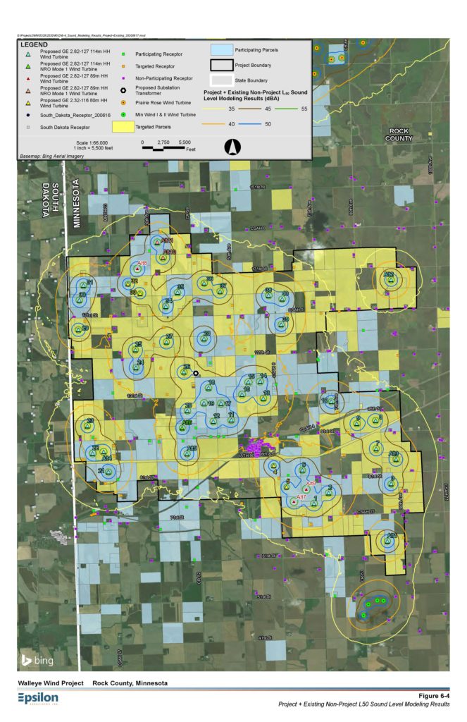
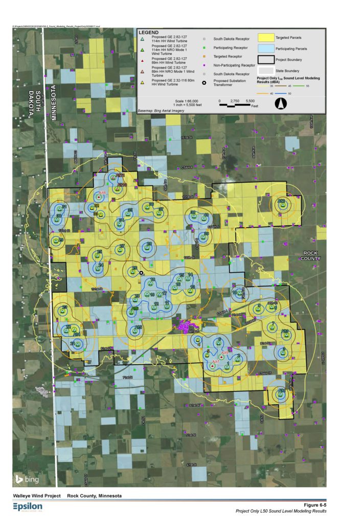
How is it determined how far the turbines need to be to comply with the noise standard, Minn. R. 7030.0400?? Since they did a “noise study” and drew lines around turbines to delineate various dB levels, shouldn’t a distance accompany these maps? From the maps it is impossible to tell, and the lines are drawn such that it looks like some lines go right through homes, some are up against the line. If this was in google earth, it would be easier to determine distances — if not provided in a chart for turbines and receptors, shouldn’t they have to provide a google earth link, kmz map, or ???
These are the noise maps from Application, Appendix B, Noise, p. 26-27 (click for larger view):
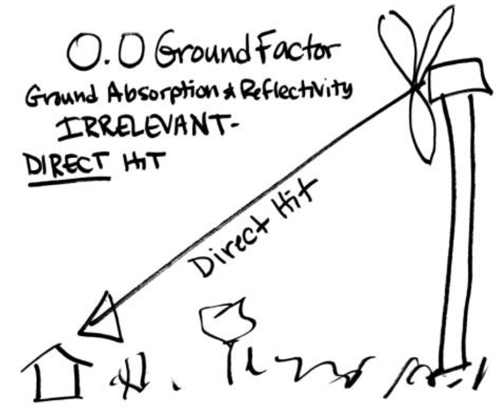
And for a more complicated issue, the noise modeling is GI/GO, using an improper ground factor as a primary assumption. Ground factor is used to address the blockage/interference of noise from a source to the “receptor.” This is important here because modeling with a ground factor, ranging from 0.0 to 1.0, with 0.0 for no interference, and 1.0 for nearly complete blockage of noise, will grossly understate potential noise if it claims a higher ground factor than warranted. Even Hankard, who did noise work on this project, agrees that a ground factor of 0.5 is not appropriate for an elevated source such as a wind turbine:
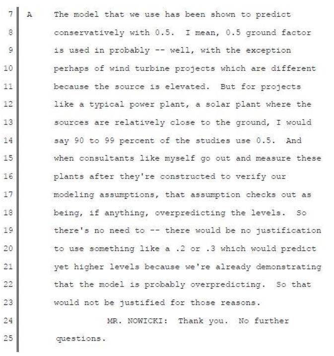
Dr. Schomer, who was part of committee that developed the ISO 9613-2 noise modeling standard had an even more specific explanation, this from another wind docket. See pps. 11-25:
This explains graphically why the 0.5 ground factor used for the Walleye Wind and other wind projects is inappropriate for an elevated source:
The danger of use of an improper ground factor that understates potential for noise is evident in the Commission’s Blazing Star wind docket (IP-6961/WS-16-686), where multiple landowners are suffering from high noise levels, unable to sleep at night, unable to use and enjoy their property. From the Compliance Filings, tracking complaints which began when the project was in start-up testing, before commercial operation, and these complaints remain unresolved over a year later:

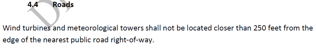
The next Draft Site Permit Setback issue is Section, 4.4 Roads, repeats the matter of origin of the setback, and more:
FYI, Walleye reduced its setback initial proposal in Application Section 8.12, from “at least 1.1 times the total turbine height from snowmobile trails to minimize the potential for ice throw,” yet changed that to just 250 feet for the Amended Application. WHAT?!?!
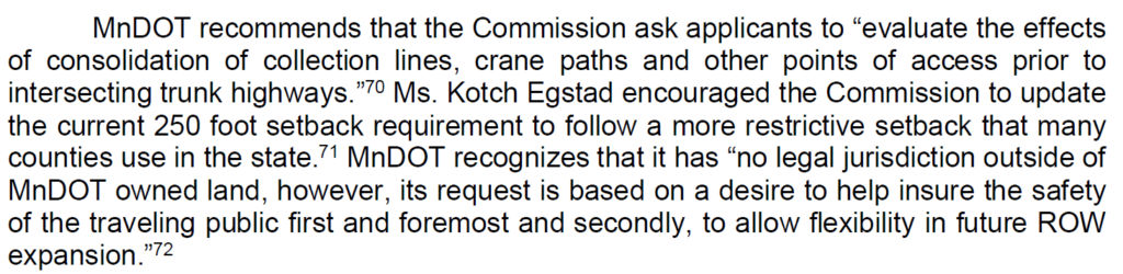
At the 2019 Power Plant Siting Act Annual Hearing, the DOT requested the Public Utilities Commission re-evaluate the 250 foot setback from roads. From the ALJ’s Report:
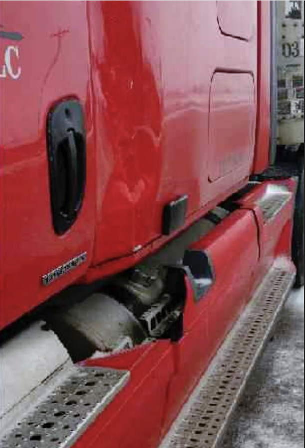
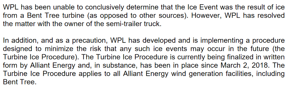
While the Freeborn Wind contested case was in session, an ice throw from a Bent Tree turbine hit a truck as it was traveling on Hwy. 13. Ironically, Bent Tree located immediately northwest from Albert Lea where our hearing was being held. 20182-140446-01_Letter Bent Tree
The Draft Site Permit, Section 4.10 also allows that “If required, up to 20 percent of the towers may be sited closer than the above spacing, but the permitee shall minimize the need to site the turbine towers closer.” WHAT?!?! No restrictions, no requirement of review and approval by Commission, they can just do it if they want to.
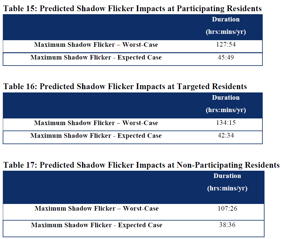
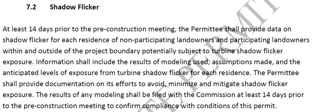
Draft Site Permit Section 7.2 does not have any limitation on hours of shadow flicker. Shadow flicker hours predicted are far, far above that typically allowed in permits, but again, there are no rules or standards for siting wind projects, and this is just Commission practice.
Here’s what their modeling predicted, from cover letter to Application Amendment, p. 17:
This is the ENTIRE Walleye Draft Site Permit Section 7.2:
This is the Freeborn Wind Site Permit Section 7.2 Shadow Flicker:
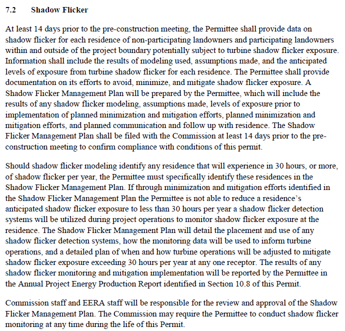
WHAT?!?!?! They’re a long way from 30 hours. Where is the shadow flicker hours limitation?
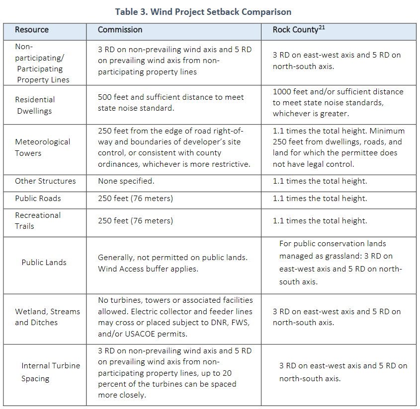
The Commerce-EERA Environmental Report, p. 13-14, provides a chart with these same siting setbacks and factors, listing “Commission” yet origin not specified — because there is only the SMALL Wind Standards, and none for LARGE wind:

****************************************
The project’s Amended Application has some oddities too:
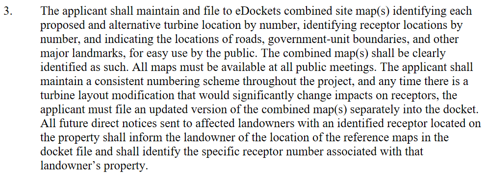
The Public Utilities Commission directed Walleye Wind to produce a clear map, as there were several iterations, and it was difficult to determine what was what:
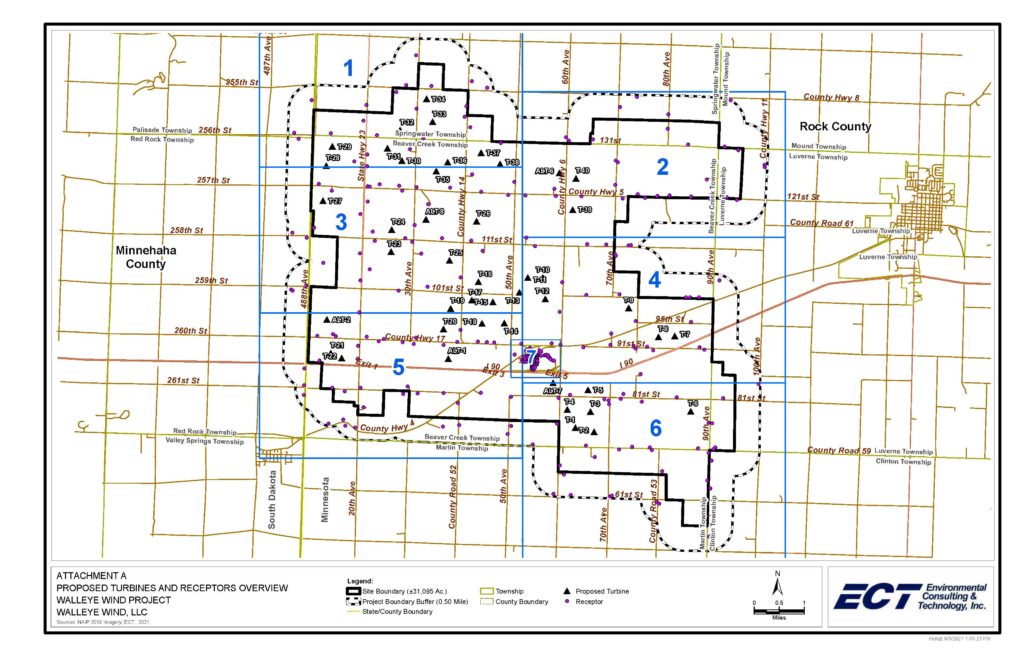
Here’s the overview MAP – click for larger version:
Here are all the maps provided to the PUC as directed:
Use these maps to determine what “receptor” number you are (I know, it’s a hugely offensive term, do let them know how you feel about that!), and what turbines are nearby. Do your best to determine distance to these turbines.
The PUC’s wind statutes and rules have very little to go on for siting criteria:
However, the Power Plant Siting Act’s siting criteria, to the extent it fits a wind project, does apply. That criteria is found in Minn. Stat. 216E.03, Subd. 7.
For example, it starts out that the Commission needs to consider:
If you have concerns regarding any of these matters, state those concerns, and dig around for studies and research (credible, peer reviewed, not histrionic blather), and cite them in your comment, and attach that study to your comment.
If you have evidence of resources that should be taken into consideration, explain, and attach a map, for instance, regarding “Visual Impacts,” Section 8.5.1, the Amended Application states:
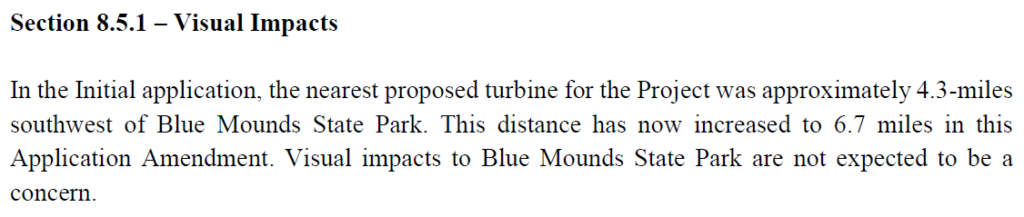
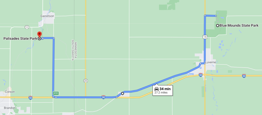
Visual impacts for a Minnesota’s Blue Mounds State Park are considered at 4.3 and 6.7 miles… what about residents and visual impacts that they will view daily?
Visual Impacts for a Minnesota’s Blue Mounds State Park are considered at 4.3 and 6.7 miles… what about Palisades State Park in South Dakota, closer to the center of the project than Blue Mounds State Park?