PUC 1/22 — Getty & Black Oak Wind
January 15th, 2015
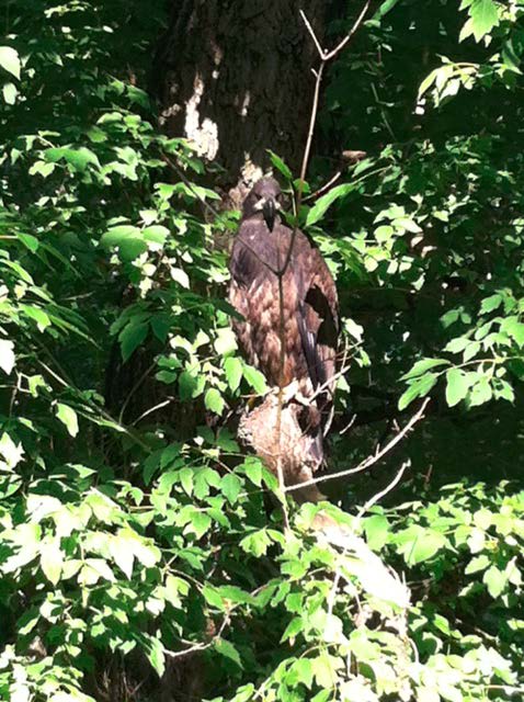 Eagle photo by Jason Jennissen, on the Jennissen property in Stearns County
Notice just came out that our Motion for Reconsideration of Amendment of the Siting Permit, issued November 14, 2014, for the Getty and Black Oak wind projects is before the Public Utilities Commission on January 22, next Thursday:
The Commission will either do nothing, take it up and make no changes, or “Reconsider,” which could mean taking action then, or pushing it forward to revisit.
We were before them in the Certificate of Need docket a couple of weeks ago, where they were saying it’s a 78 MW project (and there’s an exemption to Commission reconsideration of a Certificate of Need if it’s under 80 MW, funny how that works). 78 MW? Yes, that’s what they say in their request for Extension of the In-Service Date:
 But their permit, just amended is for 21 – 2 MW turbines and 20 – 2 MW turbines which equals 82 MW…
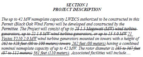
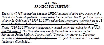 So which is it, 78 MW, where Recertification by the Commission is exempted, or is it 82 MW as stated in the permit, and where Recertification is not exempted because it’s over 80 MW?
And let’s look a little closer at potential impacts of this project:
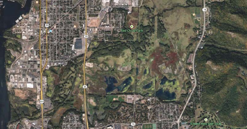
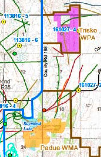 See that red dot just above the Padua Wildlife Management Area? That’s an eagle nest, recognized as such by HDR when it did the Avian Study for the Black Oak and Getty wind projects:
What’s very strange about this project is that although the DNR has submitted numerous comments in the record, and although there are references to US Fish & Wildlife by Applicants in the ABPP, there are no USFWS comments in the record that I can find.
So I fired off a FOIA request to USFWS, and they weren’t real happy with it, so I fired off another a couple days ago:
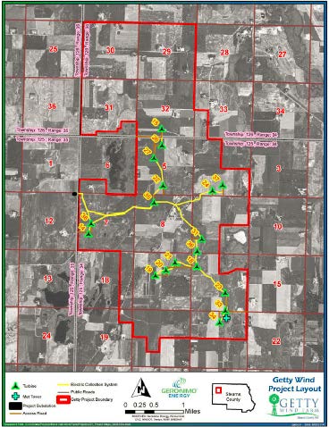
Hoping to get some good info, because as you can see above, there is an eagle nest, and as you can see on the map below, well, count the wind turbines within two miles of that eagle nest: 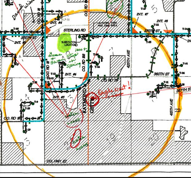
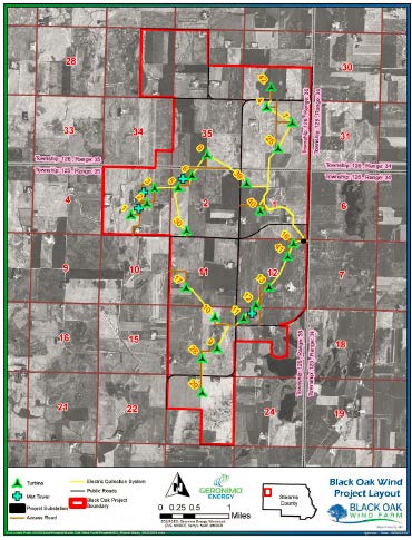
Here are the project siting maps:
An off the cuff review of the map shows the following affected turbines in Getty, where turbines are located within a two mile radius of an eagle nest:
Section 7: Turbines 14 & 38;
Section 8: Turbine 35;
Section 16: Turbine 18, and Turbine 36 RD area affected;
Section 1: Turbines 19, 20 and 21.
A similar review of the affected turbines in Black Oak:
Section 1: Turbine 40;
Section 11: Turbine 17;
Section 12: Turbines 12, 13, 14 and 16;
Section 13: Turbine 11;
Section 14: Turbines 28, 9, 10;
Section 23: Turbine 29.
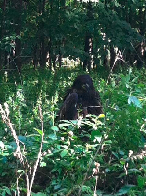 Eagle photo by Jason Jennissen, on the Jennissen property in Stearns County
Delmarva Power to rebuild transmission in DE?
January 3rd, 2015
Delaware’s a small state, and it’s just the wrong shape for getting a good transmission map. Click the above one for a larger view, but it’s still hard to see. But check it out! Take a look at that black line, stretching from Red Lion down to Milford. That’s the 230 kV line that Delmarva Power wants to rebuild. If they play this as I think they will (please prove me wrong), they could use this “rebuild” to significantly increase transfer capacity, which given the withdrawal of the Mid-Alantic Power Pathway (MAPP) transmission project, that’s something to watch for.
Public meeting about transmission line rebuild
7 p.m. Wednesday, Jan. 7, 2015
Odessa Fire Company
304 Main St., Odessa, Delaware
Hosted by Delmarva Power
There’s essentially no regulation of transmission in Delaware, a fact that’s hard to believe given the impacts and power associated with transmission. This project is intended to go right down an existing easement, but the original line was built 50 years ago, and there’s been a lot of development in Delaware since then. Look at the map, and there’s a lot of development right next to this transmission line. Do you think these folks know anything about this transmission plan? Do you think anyone along that easement is getting direct notice about this???
At first glance, a couple of things occur to me.
- Rebuild? As always, I want to know the details. they say it will still be at 230 kV. Let’s have the conductor specs, particularly. How big a conductor are they using, ACSR or ACSS or higher capacity? Will they be rebuild as a single or double circuit, and will it be bundled or not? Here’s the photo of the line, photo from Snooze Urinal, and it’s as it looks to me from driving under it numerous times on the way to/fro Port Penn:
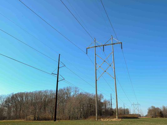 Photo from The News Journal, delawareonline.com
- Use of existing easement or extending beyond? In their press release, there’s something disturbing about how they say they’re going to build this thing:
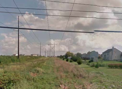
So looking at this photo above, it’s facing north, the H-frames are on the east side, the monopole on the west, and the News Journal report says:
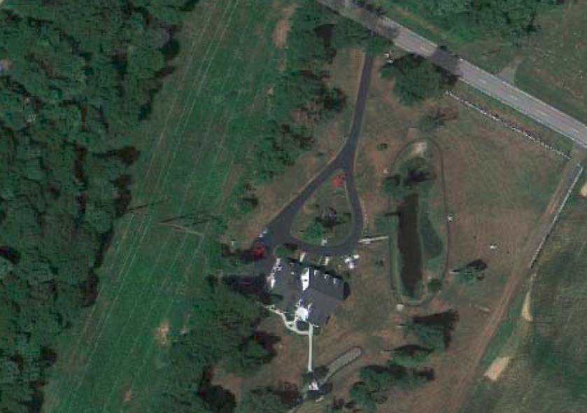
How is that possible? The H-frames have been there a long time, and rather recently they added the monopole next to it. Now now this will be “built along the eastern border of the existing right-of-way.” EH? Here’s an example, at the intersection of Port Penn Rd. and the line, the “east” is on right on this photo/map (click photo for larger version):
This is what it looks like at the road, looking down the easement with home on the left:
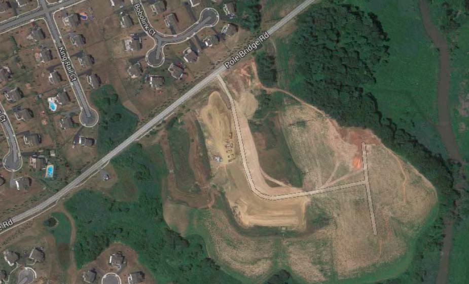
And here’s another example, at the intersection of Pole Bridge Rd. and the transmission lines, also on the way to/fro Port Penn, note the new subdivision roads, Waterbird Lane and Marsh Hawk Court:
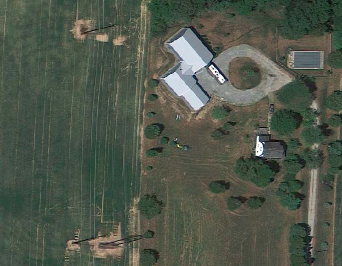
Here’s another at 955 Vance Neck Rd (the road is just to the south):
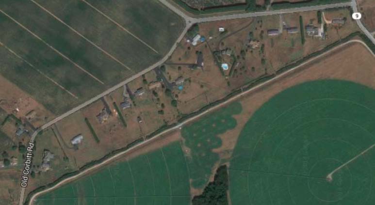
Let’s keep going further south along the easement. Here are homes along Old Corbett Rd. near the intersection of Hwy. 9 — note it’s turned around to fit better, the “easterly” direction they’ll build into is the area towards the homes:
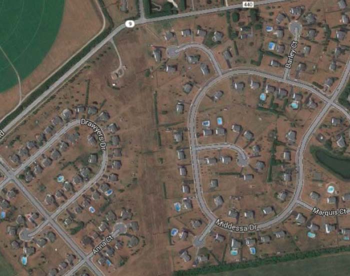
Here’s another subdivision on the other side of Hwy. 9, and the homes along Middessa Drive:
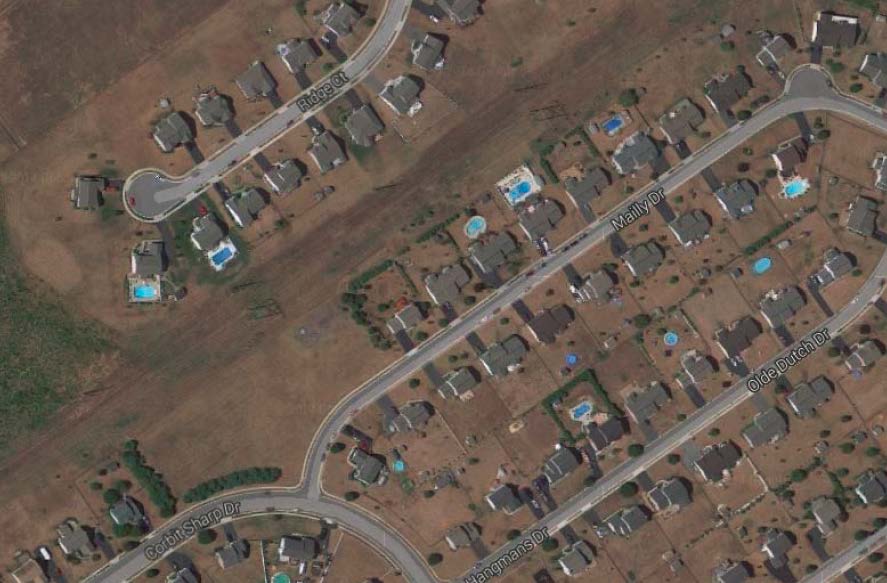
Just a little further south, where the line turns southwesterly, the line is abutted by the homes on Mailly Drive and Corbit Sharp Drive:
Here’s what that easement looks like — build this new thing on the easterly border of the easement? I think not!
And this northern Red Lion to Milford section of the transmission “rebuild” terminates at the Cedar Creek substation, technically in Townsend:
Again, do you think these folks know anything about this transmission plan? Do you think anyone along that easement is getting direct notice about this???
Here’s Delmarva’s Press Release:
Press Release 12/23/2014 – Delmarva Power Project to Benefit Delaware
Here’s the report from the News Journal:
Delmarva to brief public on transmission line rehab
The electrical spine of Delaware is set for a $70 million rehabilitation.
The utility will host a public meeting to brief the community on the project on Wednesday in Odessa.
Contact Staff Writer Xerxes Wilson at (302) 324-2787 or xwilson@delawareonline.com.
For more information:
Delmarva Power will host a public meeting at 7 p.m. Wednesday, Jan. 7, at the Odessa Fire Company, 304 Main St. in Odessa.
Speaking of rail, NTSB Safety Alert and Reports
January 3rd, 2015
Some rail safety reports and issues hot off the press from NTSB.
- Rail alert about rail warning lighting, where LED was bright and obscured the incandescent red stop light. BOOM! It’s all about “conspicuity!” SA_038_Safety Alert – Visibility-Conspicuity
- Railroad Accident Report: NTSB Report_ChafeeMO_RAR1402
- Railroad Accident Brief: NTSB Report_KeithvilleLA_RAB1414
And from the Canadian Transportation Safety Board, the report on the Lac Megantic derailment and massive explosion published in August, 2014 (can’t find that I’d posted it, how can that be? Well, here it is.)
DNR Rail Hearing – January 7 in La Crosse
January 1st, 2015
Please attend the DNR hearing on Burlington Northern’s request to build a second rail line in the La Crosse River Marsh.
2-5 p.m., Wednesday January 7
Black River Beach Center
1433 Rose Street
La Crosse, WI
https://www.youtube.com/watch?v=CgyAe2SnyUQ
More history — a stunning video:
http://insideclimatenews.org/video/boom-north-americas-explosive-oil-rail-problem
- Attend the meeting and bring friends: A room filled with concerned citizens has an impact. The press and DNR will take note. We can have an impact on the discussion and decision.
- Speak at the meeting if you are willing. You don’t have to be expert. Just say why the marsh is important to you and what your concerns are about train traffic, more of it, and the risks involved. Keep on point about the La Crosse River Marsh and the BNSF rail. This is what the meeting is for.
- Ask for an “Environmental Impact Statement” (EIS). This project warrants an EIS because of it scale, implications for safety and health, and broad public concern. An environmental expert would be hired at BNSF’s expense to assess the current use and health of the marsh, provide a baseline for future cumulative impact studies, and result in the best possible solutions if approval is given. It would be paid for BNSF.
- There is no guarantee that money BNSF pays for loss of flood plain will return to La Crosse. Ask the DNR to find a way for BNSF to pay for improvements to the Marsh to minimize the impact of lost flood plain.
- Provide written comments to the DNR before, during, or within 10 days after the meeting. A paper trail has significant impact now and for the future. Here is a link to help: Click here for help on drafting a letter.
- For citizens to make the DNR aware of the importance of the Marsh and risks of this project, to share concerns, and to ask questions.
- To provide the DNR with information to make well-informed decisions that would prevent construction of a second rail or reduce the risks and impacts.
- Rail transport of Bakken crude in unsafe DOT-111 tankers has skyrocketed to about six 100-car trains daily (430,000 barrels). Enbrige’s Alberta Clipper Pipeline carries 450,000 barrels per day. Essentially BNSF railway is a “rolling pipeline” through the Upper Mississippi Refuge and the Marsh.
- Spills are over 3 times more likely per mile by rail oil transport than by pipeline. There has been more than one spill per day from tankers this year in the US. Some have destroyed marshes and seriously polluted rivers.
- Spills into marshes are virtually impossible to clean up. There is no effective, acting model for marsh spill containment. A large spill would destroy the Marsh’s ecosystem.
- Proposed expansion would eliminate 7.28 acres of marsh, which will not be replaced in or near Myrick marsh, and may not even happen within the La Crosse watershed.
- Could increased vibration, noise, and pollution threaten habitat for species such as rare black terns and yellow headed blackbirds as well as many other species?
- Floodplain will be removed. With the increased occurrence of local flooding, is the 100-year flood criteria used by the DNR still sufficient to protect citizens? To prevent flood insurance increases?
- Could our local Hazmat team prevent a spill from spreading to the Mississippi?
- Who will pay for training for first responders?
- Who would pay for any clean-up should there be a problem?
But remember it has happened elsewhere. It’s happened recently in Lynchburg, Aliceville, Lac Megantic, and Casselton (twice in one year!). Imagine La Crosse with a fouled, dead Marsh and oil-contaminated La Crosse River flowing through the city to Riverside Park and into the Mississippi. That is the risk.
Ralph Knudson, Nancy Heerens-Knudson, Irv Balto, Marina Dvorak, Maureen Freedland, Bruce Kuehmichel, Chuck Lee, Carolyn Mahlum-Jenkins, Curtis Miller, Fred Nicklaus, George Nygaard, Rich Pein, Karen Ringstrom, Jeff Sexton, Jan Stack, Alan Stankevitz, Guy Wolf
