Dakota Access – Notice of Intent for Environmental Impact Statement
January 18th, 2017
Yes, here it is, the Federal Register link, the Notice of Intent for an Environmental Impact Statement for the Dakota Access Pipe Line, a/k/a DAPL:
Notice of Intent to Prepare an Environmental Impact Statement
Scoping comments are due by February 20, 2017. By mail, and they ask that you include your name, return address, and “NOI Comments, Dakota Access Pipeline Crossing” on the first page of your written comments:
Gib Owen
Office of the Assistant Secretary of the Army for Civil Works
108 Army Pentagon
Washington, DC 20310-0108
By email to gib.a.owen.civ@mail.mil – use Subject: NOI Comments, Dakota Access Pipeline Crossing
They say they want comments about these issues, but don’t limit your input:
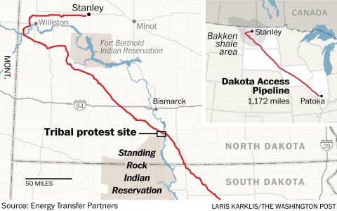
(1) Alternative locations for the pipeline crossing the Missouri River;
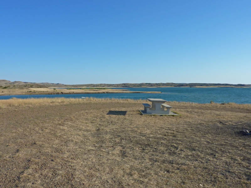
(2) Potential risks and impacts of an oil spill, and potential impacts to Lake Oahe, the Standing Rock Sioux Tribe’s water intakes, and the Tribe’s water, treaty fishing, and hunting rights; and
(3) Information on the extent and location of the Tribe’s treaty rights in Lake Oahe.
What does this mean? Well, they’re looking for a way to ram it through, looking for “alternative locations for the pipeline crossing the Missouri River.” They’re probably wanting to avoid any consideration of the entire project, avoid consideration of connected actions here, and the potential for and high risk of impacts downriver. How about need? I’ll bet they don’t want to consider whether there is need for this line, and what it means if there is increased oil output in the region, the impacts of continued extraction! Broaden the scope! From the Notice: “The range of issues, alternatives, and potential impacts may be expanded based on comments received in response to this notice and at public scoping meetings.” So get to work!
Flooding and Fort Calhoun nuclear update
June 16th, 2011
 Not much time to pull this together, but a couple of things to note before I head off to Cannon Falls for the hearing today… From my stats, it’s clear people want more information — there’s flooding,and it’s a lot:
Interview with Bernard Shanks – from KMOX – Total Information AM
“Fort Peck dam failed when it was under construction, it failed… 8 men are buried in it…”
… and in response to Shank’s claims, here’s the response from the US Army Corps of Engineers, the Ft. Peck dam operators:
If you’ve not been to Fort Peck dam, put it on your list and get there. The campground there is one of the things that will stand out in my memory forever, what a dogforsaken place it was in the 60s… The ranger came around to say hello, he’d been out shooting rattlesnakes, had a bag full, and cautioned us!
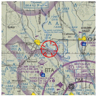
So back to the impacts of the flooding. There’s water, water everywhere… surrounding the Fort Calhoun nuclear generating plant, and it’s getting higher, the plant is now completely surrounded by water and sandbags are for now keeping it at bay. June 6, the day of the fire, a no-fly zone was declared that remains today:
And here’s the OPPD site:
Who needs rumors when we’ve got the truth!
Fukushima can’t happen here? Uh-huh… right…
June 6th, 2011
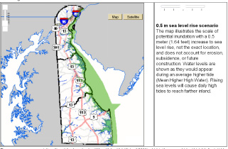
I’ve gotten a few emails questioning raising issues about our own GE nuclear reactors, like at Monticello, and they always note, “it can’t happen here.” Anyone who knows anything about nuclear knows better… and as one living in a “nuclear” community, two reactors here in Red Wing, and three in Salem, NJ, right across the river from Port Penn, I know too well the risks. Floods happen. Hurricanes happen. Salem and Hope Creek are built on a manufactured sand “island” on the Delaware River just up a tad from the Atlantic Ocean, up just enough to suck in the fresh water (and lots of fish), and close enough to be history as the sea continues to rise:
Well, folks we have a situation… the U.S. Army Corps of Engineers is releasing a lot of water from dams along the Missouri River backed up with too much rainfall, and they’ve started to evacuate parts of North Dakota, and it’ll affect South Dakota and Nebraska too.
The U.S. Army Corps of Engineers has a site: Flood Resources
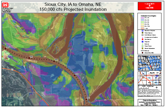
Here are the “Inundation Maps”
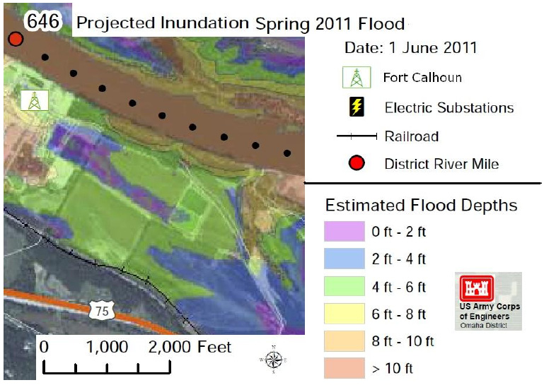
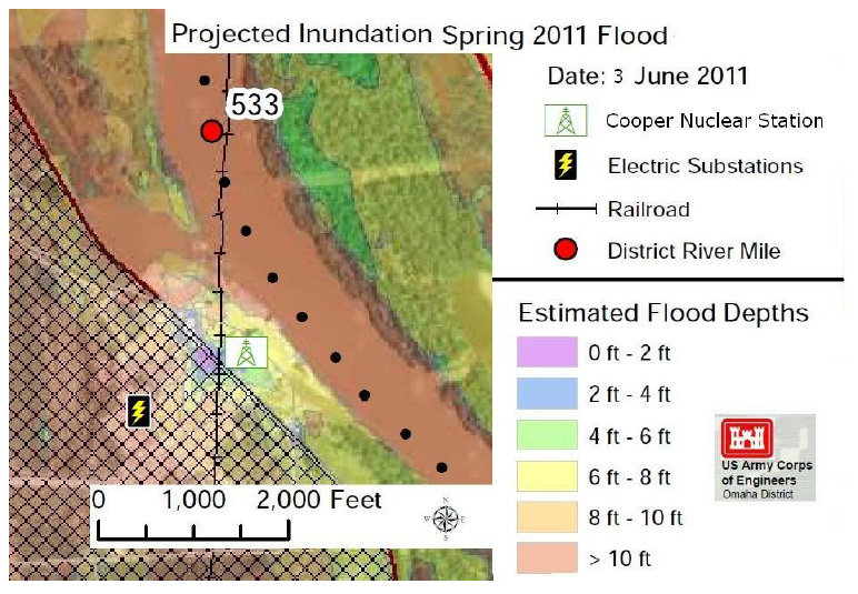
On the Sioux City, IA to Omaha, NE link, check out map Z17 and look way over in the right side for the Ft. Calhoun nuclear plant (yes, there is something in Ft. Calhoun in addition to the legendary “Ft. Calhoun Interface.”), and compare with the maps below that focus on the plants — it’s hard to miss the placement of these “critical” plants in hard to find places:
From Roger Herried today:
As a result of one of the wettest winters in over 100 years the Missouri River is threatening 6 dams that were put in place over the last 60 years to reduce annual flooding on the Missouri’s floodplain which averages between 10-20 miles across. When the area of concern was first settled by Europeans, they built their towns and farms in the fertile plain because it contained the best soil to grow food. In 1889, there was a wet year that filled the entire floodplain with a torrent that lasted for weeks. All towns and farms on the plain were washed away. The only thing left of my home town of Vermillion SD. were a few big concrete blocks of the local church. The next time they rebuilt was not on the flood plain but on the bluffs overlooking the Missouri.
Starting in the 1960’s the US Corps of Engineers constructed 6 dams on the Missouri River, the last of the six being located near Yankton SD called Gavins Point Dam. With the dams in place, everybody went back to putting farms and guess what, two nuclear power plants on the flood plain. Due to the extreme winter including major rains in May the Corp of Engineers has announced that it will be forced to release 150,000 cubic feet of water per second throughout much of June. This is five times more water than the Corp has ever had to release before, and the rainy season has not ended yet. They are suggesting that these levels will continue for much of June.
The Corps of Engineers has just released a set of projected flood maps for the area from Yankton SD throughout Nebraska showing what they think will happen in terms of controlled flood levels in the region. Based on these maps both of Nebraska’s nuclear facilities are in severe danger with the Fort Calhoun unit located 19 miles north of Omaha Nebraska and projected to be under water from 4 to over 10 feet of water (see map below). Note that in May of this year, the NRC hit Ft. Calhoun for poor flood control problems from flooding that took place last year. The facility is a 500 MegaWatt Combustion Engineering PWR reactor that is currently shut down.
The other reactor the Cooper nuclear station is located 23 miles south of Omaha and is an 830 MWe GE Mark 4 reactor and is currently at full operation. It is predicted to be under water from 4-8 feet. Behind the reactor and to the Northwest are located levees that are meant to keep at least reduce flooding by 2 feet.
Here are two maps sent by Roger Herried that identify and focus on the Ft. Calhoon and Cooper Nuclear Station nuclear generating plants:

